Gaumukh Tapovan Trek
the Gangotri Glacier, resembling a cow’s mouth (“Gau-mukh”)
Trek Grade
Moderate
Highest Altitute
14,150 ft/4312 m
Best Season
Jun/sep/oct
Trek Duration
6 Night | 7 Days
Trekking Km
46 Km
Stays
Hotel/camp
transport
Dehradun-Dehradun
trek region
Uttarakhand
Base camp
Gangotri
Meals
veg meal/egg
Trek Grade
Easy to Moderate
Highest Altitute
14,150 ft/4312 m
Trek Duration
5 Night | 7 Days
Base camp
Gangotri
Meals
veg meal/egg
Stays
Hotel-camp
transport
Dehradun
trek region
Uttarakhand
Trekking Km
46 Km
Trek Grade
Easy to Moderate
Highest Altitute
15,000 feet
Base camp
Rishikesh
Trek Duration
3D | 2N
Stays
Meals
transport
activities
How to Reach
Trek Grade
Trek Grade
Trek Grade
Trek Grade
Trek Grade
Gaumukh Tapovan Trek Overview
The Gaumukh Tapovan Trek, nestled in the Garhwal Himalayas of Uttarakhand, is one of the most spiritually and scenically rewarding treks in India. Starting from the sacred town of Gangotri, the trail winds its way through the Gangotri National Park, taking trekkers deep into the heart of the Himalayas to the Gaumukh Glacier, the source of the Bhagirathi River—one of the main headstreams of the Ganges.
The name “Gaumukh” translates to “Cow’s Mouth,” referencing the glacier’s original shape that resembled the mouth of a cow. gangotri to gaumukh trek distance is about 18 kilometers one way, reaching an altitude of around 4,000 meters, and usually takes 6–8 days to complete with acclimatization and return.
What sets this trek apart is the blend of natural grandeur and spiritual aura. Pilgrims and trekkers alike walk through dense deodar forests, over rocky moraines, and alongside roaring mountain streams. Along the way, one encounters Chirbasa (place of pine trees) and Bhojbasa (birch tree dwelling), which offer mesmerizing campsites with views of towering peaks like Shivling, Meru, and the Bhagirathi sisters. The final leg to Gaumukh is rugged and steep, traversing glacial debris, but the sight of the glacier snout and the roaring river emerging from it is awe-inspiring. Wildlife such as blue sheep, ibex, and sometimes even the elusive snow leopard inhabit the region, adding a layer of wild mystique.
Though the Gaumukh trek doesn’t require technical mountaineering skills, it does demand physical fitness, mental endurance, and proper gear due to the high altitude and cold conditions. Permits are required to enter Gangotri National Park, and only a limited number of trekkers are allowed each day to preserve the fragile ecosystem. For those seeking a deeper Himalayan experience, the trek can be extended to Tapovan, a meadow above Gaumukh that offers close-up views of Mount Shivling and is often used as a base for mountaineers.
In essence, the Gaumukh Trek is not just an adventure; it’s a pilgrimage to the origins of the Ganges, an immersion in the Himalayas’ raw beauty, and a journey that leaves trekkers transformed both physically and spiritually.
Gaumukh Trek Key Highlights
Gaumukh Glacier (Source of the Ganges)
- The snout of the Gangotri Glacier, resembling a cow’s mouth (“Gau-mukh”), is the origin of the Bhagirathi River, which becomes the Ganges.
- A site of deep spiritual importance and natural wonder.
Gangotri National Park
- Trek through a pristine Himalayan ecosystem rich in flora and fauna, including blue pine, birch, deodar, and animals like bharal (blue sheep) and Himalayan ibex.
- The park is a protected area, adding ecological and conservation value to the trek.
Stunning Mountain Views
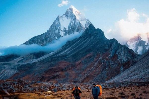
- Panoramic vistas of Mount Shivling, Bhagirathi I, II, III, Mount Meru, and other high Himalayan peaks.
- Especially breathtaking from Tapovan, a high-altitude meadow above Gaumukh.
Tapovan Extension (Optional)
- A tranquil meadow located at around 4,300 meters, often used as a base camp by mountaineers.
- Tapovan Known for its spiritual energy, it’s ideal for yoga, meditation, and quiet reflection amidst the mountains.
Campsites like Chirbasa & Bhojbasa
- Chirbasa: Nestled among chir (pine) trees, offering a peaceful forested setting.
- Bhojbasa:Wide-open valley near the river with stunning sunset views and the last overnight stop before Gaumukh.
Spiritual & Mythological Significance
- The route traces a pilgrimage trail that saints and sages have walked for centuries.
- The area is considered one of the holiest in Hinduism, closely associated with the goddess Ganga.
Challenging Yet Accessible Trek
- Moderate to difficult in terms of terrain and altitude, but manageable with good fitness.
- No technical climbing required, making it suitable for fit beginners and seasoned trekkers alike
Incredible Photography Opportunities
- Wildlife, wildflowers, and dramatic Himalayan skies offer endless visual appeal.
- From icy glaciers and rugged moraines to golden sunrises over snow-capped peaks.
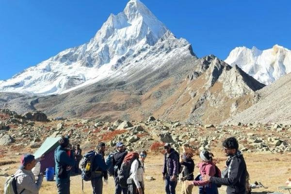
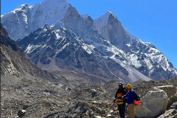
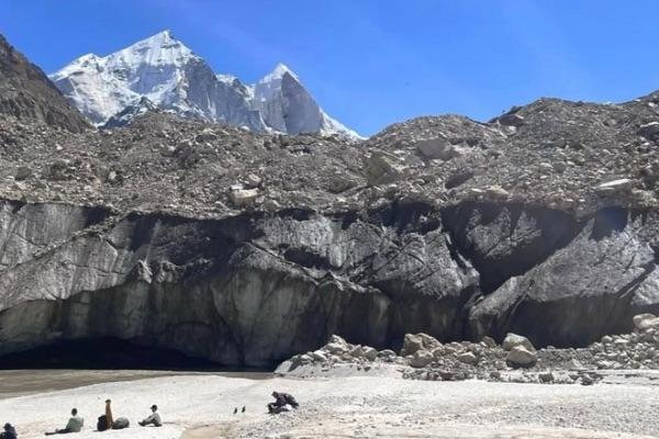
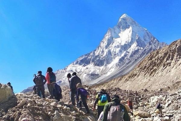
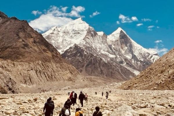
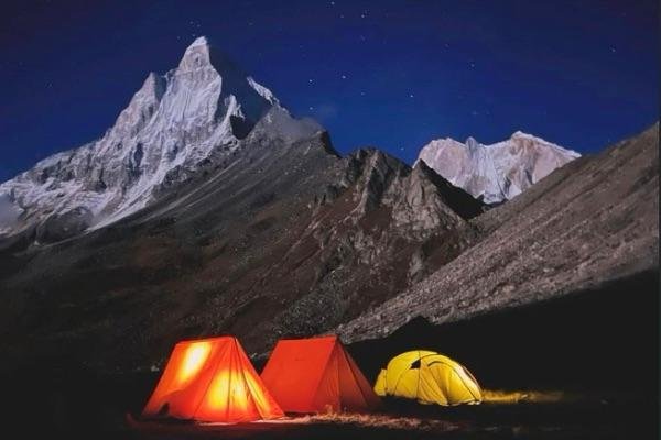
Gaumukh Tapovan Trek Photos
Gaumukh Tapovan Trek Route Itinerary
Daily Hiking Schedule of Gaumukh Tapovan trek
Day 1 Dehradun to Base Camp Gangotri
(250 km Drive, 9-10 hrs approx)
Dehradun to Base Camp Gangotri
(250 km Drive, 9-10 hrs approx)- Stay : Overnight stay in Guest house at Gangotri
- Meal : Tea snacks, Dinner.
- Altitude : Gangotri (3139 m)(10300 ft)
- Distance : By road 250 km.
- Time Taken : By road 9-10 hrs approx.
- Trek Grade : By Road
Travel from Dehradun to Gangotri – A Scenic Drive Through the Himalayas
The journey to Gangotri starts early in the morning from Dehradun, a busy city known as the entrance to the Uttarakhand Himalayas. Leaving around 6 a.m. from Prince Chowk, you begin a beautiful drive through the mountains. The road winds through valleys, with tall hills on both sides, and you’ll pass by freshwater streams and waterfalls that add to the charm of the trip.
After about 35 kilometers, you’ll reach Mussoorie, a well-known hill station called the “Queen of the Hills.” Located at about 2,000 meters above sea level, Mussoorie offers lovely views of the Shivalik hills and the Doon Valley. The town is known for its cool weather, British-era buildings, and lively shops. You might stop here for breakfast and enjoy the peaceful views.
As the road climbs higher, you’ll reach Uttarkashi, a town by the Bhagirathi River that holds religious importance. It’s known for its temples and ashrams, especially the Kashi Vishwanath Temple, which is dedicated to Lord Shiva. This town is also a common stop for trekkers heading into the Himalayas.
Next, you’ll pass through Harsil, a quiet village surrounded by tall deodar trees and apple orchards. With its wooden houses and clean mountain air, Harsil feels calm and untouched. It’s often called one of the hidden treasures of Uttarakhand, offering peaceful views of snowy peaks and thick forests.
From Harsil, the road follows the Bhagirathi River. The sound of the flowing water and the changing mountain scenery make this part of the trip very special. As you get closer to Gangotri, the views become more stunning, giving you a sense of the spiritual journey ahead.
By evening, you’ll reach Gangotri, a small town located at around 3,100 meters altitude. It’s one of the four sacred Char Dham sites and is home to the famous Gangotri Temple, where people come to pray to Goddess Ganga. The river Ganga is believed to have started from here. Once you arrive, you can check in to your guesthouse, enjoy the peaceful surroundings, and take a walk near the river or explore the local shops filled with prayer items and souvenirs. After dinner, you’ll rest for the night and get ready for the trek to Gaumukh the next day.
Day 2 Trek from Gangotri to Chirbasa
(7 kms trek, 4-5 hrs approx)
Trek from Gangotri to Chirbasa
(7 kms trek, 4-5 hrs approx)- Stay: Overnight stay in tents at chirbasa
- Meal: breakfast, packed lunch, evening tea snacks, soup and dinner.
- Altitude: Chirbasa (1170ft), (3566m)
- Distance: By Trek 7 km.
- Time Taken: By Trek 4-5 hrs approx.
- Trek Grade: Gradual
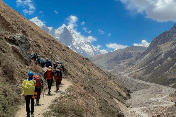
Today, the adventure continues as you begin your trek from Gangotri to Chirbasa. After enjoying a healthy breakfast, you’ll walk for about 30 minutes to reach a forest checkpoint. Here, your permits will be checked as part of the rules for entering Gangotri National Park.
Once cleared, the trail turns left. On one side, you’ll see tall pine trees, and on the other, steep and rocky mountains. The Bhagirathi River flows right next to the path, and its fast-moving, clear water adds a calm and peaceful feeling to the walk.
The path goes up slowly, making the trek fairly easy and pleasant. It takes about 5 to 6 hours to reach Chirbasa. Along the way, you’ll pass by small streams and waterfalls, which not only make the view more beautiful but also give you a chance to refill your water bottles.
As you climb higher, you’ll see the impressive Sudarshan Parbat, a mountain that rises to 21,345 feet. The trail stays within Gangotri National Park, which is known for its clean environment and rich plant and animal life.
Chirbasa is located at a height of 3,550 meters and is your first campsite. The name ‘Chirbasa’ means “Place of Pines,” and true to its name, the site is surrounded by tall pine trees. The fresh smell of the trees and the open views of the mountains make it a lovely place to rest.
From here, you’ll also see the famous Bhagirathi peaks – I, II, and III – for the first time. After setting up camp, you can relax, take a short walk, or simply enjoy the peaceful nature. You’ll have a warm lunch, and in the evening, you can spend some quiet time near the Bhagirathi River, getting used to the altitude and preparing for the days ahead.
Day 3 Trek from Chirbasa to Bhojbasa
(6 kms trek, 4-5 hrs approx)
Trek from Chirbasa to Bhojbasa
(6 kms trek, 4-5 hrs approx)- Stay: Overnight stay in tents at Bhojbasa
- Meal: breakfast, packed lunch, evening snacks, shup and dinner.
- Altitude: Bhojbasa(12,450 ft), (3794 m)
- Distance: By Trek 6 km.
- Time Taken: By Trek 4-5 hrs approx.
- Trek Grade: Gradual
Today’s trek from Chirbasa to Bhojwasa is shorter and easier compared to the previous day. It takes about 3 to 4 hours with a gentle uphill trail. As you walk, the surroundings start to change—the green forest begins to thin out, and the path becomes more rocky and dry. You’ll notice fewer trees and more open, wide views of the mountains, giving you a real sense of the high-altitude wilderness.
The trail has a few rocky patches and steeper parts, but overall it’s a steady and manageable climb. As you move forward, the Bhagirathi peaks come into better view, standing tall and clear against the sky. The Bhagirathi River flows beside the trail, offering a calming sound and a splash of life against the rough landscape.
Bhojwasa means “home of the bhoj trees,” though most of those trees are gone now. What remains is a vast, open plain with a backdrop of dramatic peaks. The area feels remote and wild, making it a perfect place to connect with the raw beauty of the Himalayas.
On the way, you’ll pass through different terrains—some loose stones, small stream crossings, and even a few landslide-prone zones. Be cautious here, especially if the weather changes. Stay alert for falling rocks and uneven paths. Keep your eyes open—you might spot blue sheep grazing on the slopes or catch a glimpse of colorful Himalayan birds.
When you reach Bhojwasa, you’ll find a few simple places to rest, including the Lal Baba Ashram, a peaceful spot where many trekkers stop. There’s a space to camp for the night. You can spend the rest of the day relaxing, exploring, or just enjoying the quiet beauty of this mountain valley. Take this time to rest well—you’ll need your energy for the more challenging Tapovan trek tomorrow.
Day 4 Trek from Bhojbasa to Tapovan
(8 kms trek, 7-8 hrs approx)
Trek from Bhojbasa to Tapovan
(8 kms trek, 7-8 hrs approx)- Stay: Overnight stay in camp site at Tapovan
- Meal: breakfast, packed lunch, snaks, soup and dinner.
- Altitude: Tapovan(14,150 ft), (4313 m)
- Distance: By Trek 8 Km
- Time Taken: 7-8 hrs approx.
- Trek Grade: Gradual
Trek from Bhojwasa to Tapovan via Gaumukh – The Most Memorable Day
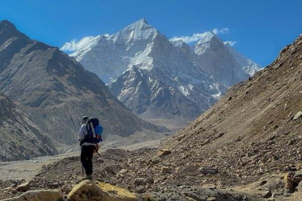
This is the most special day of the trek, as you move from Bhojbasa to Tapovan, passing through Gaumukh, the holy place where the Ganga River begins. The path from Bhojwasa to Gaumukh is a bit rocky and uneven, with a gentle climb. It’s not too hard, but you’ll need to watch your step. As you walk, you’ll soon see the snout of the glacier, where the Bhagirathi River flows out from a mix of ice and rocks—an incredible sight.
To continue toward Tapovan, you’ll need to cross the river. Since there is no bridge here, a manual trolley system is used. It’s a simple but clever setup—a metal basket or cart tied to a rope stretched across the river. One person sits in the cart while others pull it across by hand using a rope. Everyone in the group takes turns, and it usually takes around an hour for all to cross. This crossing is not only useful, but it’s also a fun and unforgettable part of the trek. People often enjoy helping out and working together, which creates a great sense of team spirit.
After crossing the river, the walk to Tapovan becomes steeper and more challenging. You’ll pass over rocky ground, glacier sections, and small water streams. It’s a tougher stretch, so take your time and be careful.
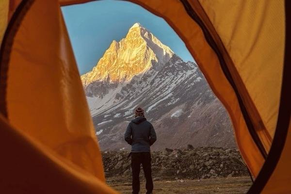
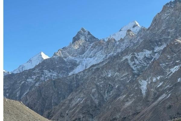
When you finally reach Tapovan, you’ll be welcomed by a wide open meadow, surrounded by snow-covered peaks like Shivling, Bhagirathi I, II, III, and Meru. The area is peaceful and quiet. Many sadhus (holy men) come here to meditate, and climbers use it as a base camp for climbing Mt. Shivling.
Here, you’ll set up camp, enjoy a hot meal, and take in the stunning views. The hike might feel long and tough, but standing in Tapovan, with the towering mountains around you, makes every step worth it.
Day 5 Trek from Tapovan to Bhojwasa via Gaumukh
(8 kms trek, 6-7 hrs approx)
Trek from Tapovan to Bhojwasa via Gaumukh
(8 kms trek, 6-7 hrs approx)- Stay: Overnight stay in camp site at Bhojwasa
- Meal: breakfast, packed lunch, snaks, soup and dinner.
- Altitude: (1 2480 ft),(38,00 m )
- Distance: 8 km Trek
- Time Taken: 6-7 hrs approx.
- Trek Grade: Gradual
Tapovan to Bhojwasa – A Journey Back Through Sacred Lands
After breakfast and one last look at the stunning views of Tapovan, it’s time to head back down toward Bhojwasa. The trail is tough in the beginning, with rocky paths and loose stones that can move under your feet, so you’ll need to walk carefully and stay focused.
As you make your way down, you’ll pass Gaumukh, the holy glacier where the Ganges River begins. Its name means “Cow’s Mouth” because the end of the glacier looks like a cow’s face. This is where the Bhagirathi River starts, which later joins with other rivers to form the Ganges. The glacier is huge and beautiful, with ice that glows in shades of blue and white.
Standing in front of Gaumukh is a powerful moment. It’s not just a place of natural beauty, but also a spiritual site for many. The rocky and icy landscape around it feels wild and special, making you think about the meaning of the river and the journey you’ve taken.
After Gaumukh, the trail gets a little easier, but you still need to be careful as you walk through the rocky paths. When you finally reach Bhojwasa, you’ll feel both tired and proud. It’s a peaceful place to rest, with the calm Bhagirathi River flowing nearby.
The afternoon at Bhojbasa is quiet and relaxing. It’s a good time to sit back, think about the amazing journey so far, and enjoy the peaceful surroundings of this lovely campsite in the mountains.
Day 6 Bhojwasa to Gangotri
(14 kms trek, 6-7 hrs approx)
Bhojwasa to Gangotri
(14 kms trek, 6-7 hrs approx)- Stay: Overnight stay in hotel at Gangotri
- Meal: breakfast, packed lunch, snaks, soup and dinner.
- Altitude: (10300 ft), (3139 m)
- Distance: Trek 14 km
- Time Taken: 6-7 hrs approx
- Trek Grade: Gradual
Bhojwasa to Gangotri – The Last Day of the Trek
Today is the final day of your trek, and it comes with a mix of emotions—sad to leave the mountains, but happy to have completed the journey. The walk from Bhojwasa back to Gangotri is about 14 km and takes around 6 to 7 hours. As you follow the Bhagirathi River down the valley, you’ll walk the same trail you came up, giving you a chance to enjoy the views once more.
The path takes you through the tall pine trees of Chirbasa, and the rocky mountain scenery slowly turns into a softer, greener landscape. It’s a long walk, but peaceful. Be careful in places where the trail is narrow or where rocks might fall. Along the way, you can enjoy the fresh air, small waterfalls, and clear mountain streams.
As you walk, the tall snowy peaks slowly disappear behind you. You may feel a little sad to leave them, but also proud of everything you’ve done. You’ve completed a special and beautiful trek in the Himalayas.
When you reach Gangotri, you’ll feel a great sense of achievement. You can visit the Gangotri Temple again to give thanks, or just take some time to rest. After days in the mountains, it feels good to be back in a place with warm food and a cozy bed.
In the evening, enjoy a nice dinner at your guest house and take a rest.
Day 7 Gangotri to Dehradun – Return Journey
(250 km Drive 9-10 hrs approx)
Gangotri to Dehradun – Return Journey
(250 km Drive 9-10 hrs approx)- Meal: breakfast
- Distance: Drive 250 km
- Time Taken: 9-10 hrs approx.
- Trek Grade: by road
Your final day begins with a warm cup of tea and a hearty breakfast in the peaceful town of Gangotri. Take a moment to say goodbye to the majestic mountains that have been your companions throughout the trek.
The drive back to Dehradun takes around 8 to 9 hrs, following the Bhagirathi River through scenic towns like Uttarkashi and Mussoorie. Along the way, enjoy the beautiful views of valleys, forests, and mountain peaks.
You’ll reach Dehradun by late afternoon or early evening. With the trek complete, it’s time to head home—carrying unforgettable memories and the joy of completing the Gaumukh Tapovan Trek.
- Stay is included on all days of the trek.You will be staying in tents on a triple/Quad sharing basis.
- Transport charges from Dehradun to Dehradun.
- All meals from dinner at Gangotri on Day 1 to tea/Coffee on Day 7 are included. Meals are simple, nutritious and vegetarian.
- All the trek equipment will be included like a sleeping bag, kitchen & dining tent, utensils, mattress, toilet tent, and crampon (if needed).
- First aid medical kits, oxygen cylinder and stretcher.
- All fuel charges, toll taxes and needed forest entry fees along with permits.
- Mountaineering qualified and professional trek leader, guide, cook and support staff.
- GST 5% (it is Mandatory)
- Any emergency evacuation charges
- Any services that are not mentioned in the cost inclusion section.
- Any Meals/accommodation beside the itinerary or not mentioned in the program.
- Any services of pony/horses and potter it will be an additional cost
- Any Bus / Airfare to/from trek start/end point
Best time to do Gaumukh Tapovan trek
The best time to undertake the Gaumukh Tapovan Trek is during the summer months from May to mid-June and again in the autumn months from mid-September to October.
Gaumukh Tapovan in Summer (May to mid-June):
- In May to mid-June, the region starts to warm up after the harsh winter, and the snow begins to melt.
- This is a popular time as the trails are accessible, and the surrounding valleys come alive with blooming wildflowers and rhododendrons
- Daytime temperatures are pleasant, though nights can still be cold, especially at higher altitudes. The rivers are relatively calm, though some may start swelling due to glacial melt, requiring caution during water crossings.
Gaumukh Tapovan in Autumn (Mid-September to October):
- The post-monsoon season from mid-September to October is arguably the best time for photographers and those seeking crisp, panoramic views of peaks like Mt. Shivling and the Bhagirathi group.
- The monsoon rains would have cleared the dust and pollution from the atmosphere, offering unmatched visibility.
- The trails are stable again, and the weather is generally dry, although temperatures begin to dip as winter approaches.
How to Reach for Gaumukh Tapovan Trek?
guide to help you to reach Dehradun from delhi for your gaumukh tapoan trek
Delhi to Dehradun by Bus
- From Delhi, a regular bus service operates to Dehradun. The main bus station in Delhi is ISBT Kashmere Gate, offering both AC and non-AC buses for the journey to Dehradun.
Delhi to Dehradun by Flight
- The closest airport to reach Dehradun by flight is Jolly Grant Airport, located approximately 25 km from the city. Regular flights from Delhi to Dehradun are available. If you plan to arrive by flight, it’s advisable to schedule your arrival one day in advance.
Delhi to Dehradun by Train
- To reach Dehradun from Delhi by train, start by heading to one of the major railway stations in Delhi, such as New Delhi Railway Station or Hazrat Nizamuddin Railway Station. Several trains operate on this route.. The journey typically takes around 5 to 6 hours. It’s advisable to check the train schedules and book your tickets in advance through the Indian Railways website or a reliable travel app. Once you arrive at Dehradun Railway Station, you can easily find local transport, like taxis or auto-rickshaws, to reach your destination in the town.
What to Pack for Your Gaumukh Tapovan Trek:
As a trekking, adventure, and travel company, we often receive inquiries from our trekkers, and one of the most frequent questions is what to pack for the Gaumukh Tapovan trek. Sometimes, it can be challenging to provide detailed explanations, so we’ve compiled a comprehensive packing list that will be beneficial for all trekkers heading to the Himalayas. When preparing for a trek and organizing your gear, it’s helpful to follow a systematic approach. You can start either from head to foot or foot to head, ensuring you cover all essentials and minimize the risk of forgetting important items. So, take it step by step and pack accordingly.
Footwear and Backpack
✅Trekking shoes with ankle support
✅Backpack with rain cover
✅Daypack with rain cover
Warm Layers and Clothing
✅Warm layers (Padded jackets )
✅3 layers for spring, summer, and monsoon treks (1 woolen sweater, 1 fleece, 1 padded jacket)
✅4 layers for autumn treks (1 woolen sweater, 2 fleece, 1 padded jacket)
✅5 layers for winter treks (1 pair of thermals, 1 woolen sweater, 2 fleece, 1 padded jacket)
✅3 Collared T-shirts (Wear one, carry two)
✅2 quick-dry trek pants (Wear one, carry one)
Accessories
✅Sunglasses
✅Sun cap, preferably with flaps
✅Waterproof gloves
✅Balaclava
✅Woolen socks (2-3 pairs od Dry + 1 pair of Woolen))
✅Headlamp
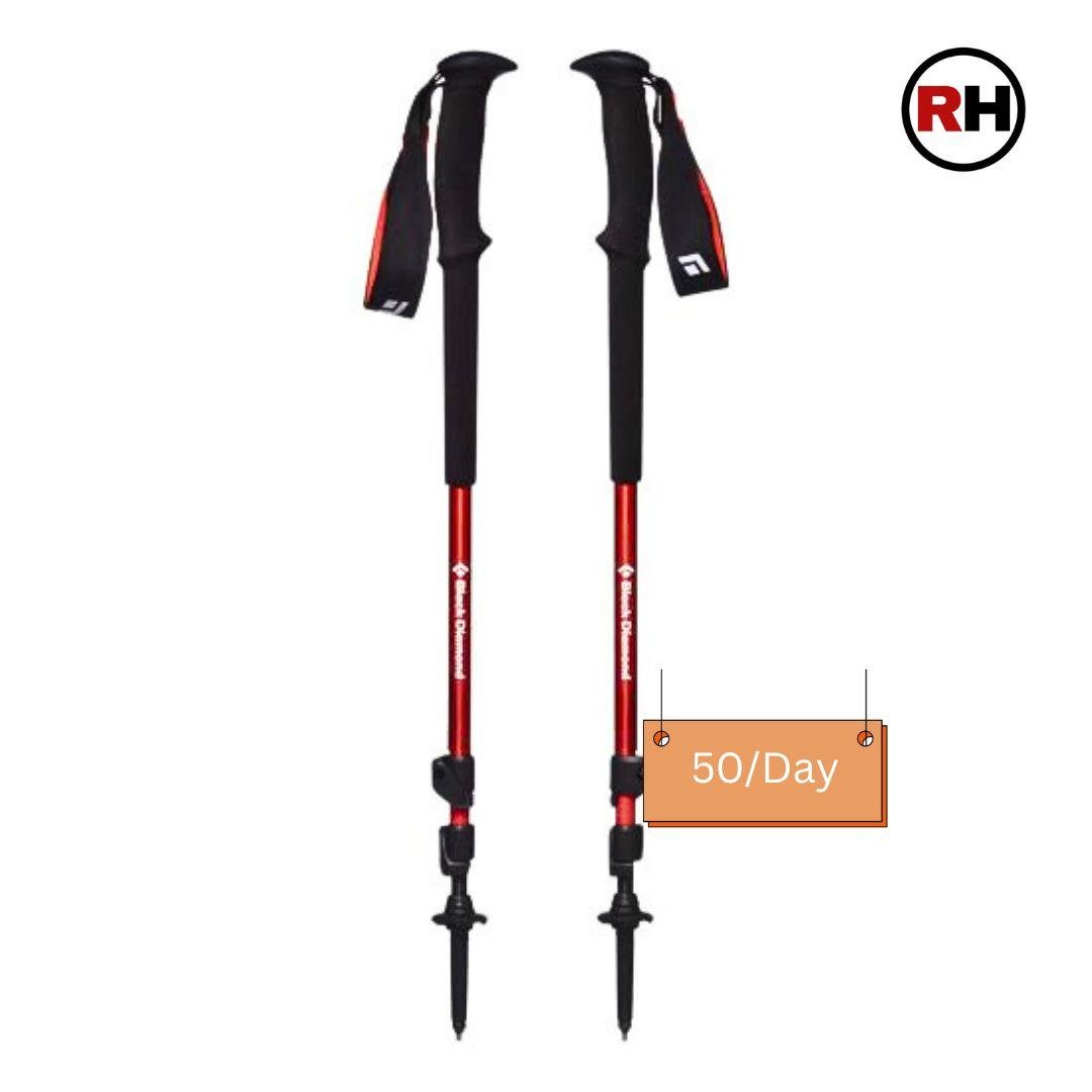
✅Trekking pole
✅Rain Jacket + pants/poncho
Toiletries
✅Suncreen
✅Moisturizer
✅Light towel
✅Lip balm or vaseline
✅Toilet paper (wet wipes are strictly not allowed on our treks)
✅Toothbrush
✅Toothpaste
✅Reusable plastic covers (for used clothes)
✅Trash bags (Carry out all your waste and leave no trace behind)


Frequently Asked Questions Of Gaumukh Trek
All The Questions About Gaumukh tapovan Trek
When is the best time to do the Gaumukh Tapovan trek?
The best time to go for the Gaumukh Tapovan trek is during the pre-monsoon months of May to mid-June and the post-monsoon period from mid-September to late October. During these windows, the weather is relatively stable, and the skies are usually clear, offering breathtaking views of majestic Himalayan peaks like Mt. Shivling and the Bhagirathi group. In summer, the snow begins to melt, revealing lush green meadows and making the glacier more accessible. Autumn, on the other hand, brings crisp air and stunning golden hues to the landscape, especially around Tapovan. These seasons offer the most pleasant trekking conditions with manageable temperatures and safer trails. The monsoon season, from late June to early September, is best avoided due to frequent rains, slippery paths, and the risk of landslides. Similarly, the winter months from November to April are extremely cold, with the trail covered in snow and high chances of avalanches, making it unsafe and generally inaccessible.
Is prior trekking experience required for the Gaumukh Tapovan Trek?
Prior trekking experience is not strictly required for the Gaumukh Trek, but it is highly recommended, especially if you’re not used to high-altitude hiking. The trek is considered moderate to challenging, mainly due to the Gaumukh tapovan altitude (up to around 4,400 meters or 14,400 feet), long walking distances, and rugged terrain, including glacier crossings and steep ascents. While fit beginners can attempt it with proper preparation, they should be comfortable walking for 5–7 hours a day and be in good physical condition. Acclimatization is key to avoiding altitude sickness, and it’s wise to train beforehand with regular cardio, strength workouts, and ideally some shorter treks. Hiring a guide or joining an organized group also helps ensure safety and support throughout the trek.
How difficult is the Gaumukh Tapovan Trek?
The Gaumukh Tapovan trek is considered moderate to challenging in terms of difficulty. It involves trekking to high altitudes—reaching up to 4,400 meters (14,400 feet) at Tapovan—and covers a distance of about 46–50 kilometers (round trip) over 6 to 8 days. The trail includes a mix of steep ascents, rocky terrain, moraines, and even a glacier crossing near Gaumukh, which can be physically demanding and requires good balance and stamina.
The high altitude poses a risk of acute mountain sickness (AMS), especially for those who ascend too quickly or are not well-acclimatized. The thin air can make even moderate physical activity feel more intense. Weather conditions can also be unpredictable, with cold temperatures and sudden changes, particularly at higher elevations.
While no technical climbing skills are needed, good physical fitness, endurance, and mental preparedness are essential. Those with prior high-altitude trekking experience will find it easier to manage. Beginners can attempt the trek too, but they should undergo proper training and consider going with a certified guide or trekking group for safety.
What is the duration and how long is the Gaumukh Tapovan Trek?
The Gaumukh Tapovan trek typically takes 6 to 8 days to complete and covers a distance of around 46 to 50 kilometers round trip. The trek usually begins from Gangotri, with the route passing through Chirbasa, Bhojbasa, Gaumukh (the snout of the Gangotri Glacier), and finally reaching Tapovan, a high-altitude meadow known for its stunning views of Mount Shivling and the surrounding Himalayan peaks. Most itineraries include time for acclimatization at Gangotri and sometimes a rest day at Tapovan to explore or recover. The trekking distance is about 23 to 25 kilometers one way, and the duration allows for a steady pace, helping trekkers adjust to the high altitude and enjoy the scenic beauty along the trail. While some experienced trekkers may complete the journey in fewer days, it is generally advisable to allow enough time for acclimatization and safe trekking.
Will there be electricity at the campsites on the trek?
No, there is no electricity at the campsites on the Gaumukh Tapovan trek. Once you leave Gangotri, you enter a remote high-altitude region with no access to power lines or charging facilities along the trail. Campsites like Chirbasa, Bhojbasa, and Tapovan are basic and set up in the wilderness, often with just tents and minimal infrastructure.
If you’re carrying electronics like a phone, camera, or GPS device, it’s highly recommended to bring power banks or solar chargers. Also, use your devices in battery-saving modes to make them last longer. Gangotri is the last place where you’ll reliably get electricity, so it’s best to fully charge everything before starting the trek.
Is Gaumukh Tapovan trek safe?
Yes, the Gaumukh Tapovan trek is generally safe for well-prepared trekkers, but it does come with certain risks due to its high-altitude and remote location. The trek reaches elevations of around 4,400 meters (14,400 feet), where the risk of altitude sickness is real, especially if you ascend too quickly or don’t acclimatize properly. The trail also involves crossing glaciers, rocky moraines, and narrow paths, which can be physically demanding and potentially hazardous in poor weather.
That said, the trek is non-technical (no mountaineering gear or climbing required), and many people—including fit beginners—successfully complete it each year with proper preparation. Going with a registered guide or trekking company increases safety significantly, as they are familiar with the terrain and trained to handle emergencies. It’s also important to check weather conditions, carry adequate gear, stay hydrated, and allow time for acclimatization.
In summary, the Gaumukh Tapovan trek is safe if done with preparation, caution, and respect for high-altitude conditions.
Is a mobile network available on the Gaumukh Tapovan Trek?
Mobile network coverage on the Gaumukh Tapovan trek is extremely limited. At the starting point in Gangotri, you might get a weak and intermittent signal, mainly from BSNL or sometimes Jio, but data connectivity is usually poor or nonexistent. Once you leave Gangotri and move deeper into the trail—towards Chirbasa, Bhojbasa, Gaumukh, and Tapovan—there is no mobile network coverage at all. The entire trekking route beyond Gangotri is remote and off-grid, so you won’t be able to make calls or
access the internet. It’s important to inform your family or emergency contacts in advance that you’ll be out of reach for several days. Some organized trekking groups carry satellite phones for emergencies, but these are not commonly available for individual trekkers. If staying connected is critical, carrying a personal satellite communication device is an option, though most trekkers manage without it.
Gaumukh Tapovan Trek Cost
Gangotri to Gangotri
Add ons
Total: ₹