Flowers You Can Only See in the Valley of Flowers Trek
Valley of Flowers Trek Overview
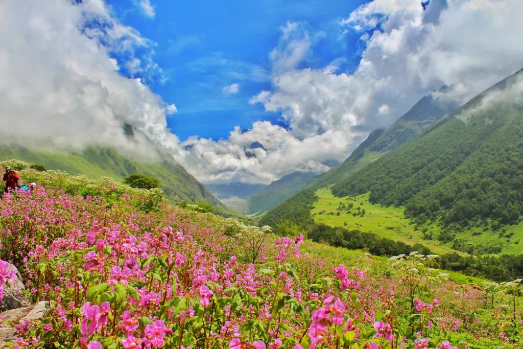
The Valley of Flowers is one of the most beautiful places in the Indian Himalayas. Located in Chamoli district, Uttarakhand, this UNESCO World Heritage Site is famous for its colourful alpine meadows, snow-covered peaks, waterfalls, and hundreds of rare Himalayan flowers that bloom during the monsoon season.
The story behind its discovery is genuinely interesting. In 1931, when British mountaineer Frank S. Smythe, along with his companions Eric Shipton and R.L. Holdsworth, lost their way while coming back from climbing Mount Kamet. They accidentally walked into this valley and found it so full of flowers that they simply named it the “Valley of Flowers.” and later introduced it to the world through his book. Before that, local villagers knew the valley existed but rarely went inside, since old stories said fairies (called Apsaras) lived there and could keep visitors trapped forever.
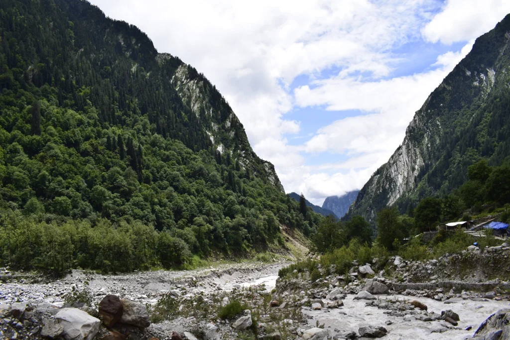
The valley sits at an altitude of around 3,600 metres (11,800 ft), while the surrounding mountains rise above 6,000 metres. The Pushpawati River flows right through the middle, fed by melting ice from the Tipra Glacier above. Because it’s shaped like a bowl carved out by old glaciers, the valley traps just the right amount of moisture and sunlight for flowers to grow — not too hot, not too dry.
In 2005, the Valley of Flowers was declared a UNESCO World Heritage Site because of its incredible biodiversity and rare Himalayan plants. To protect this fragile ecosystem, visitors are allowed to explore the valley only during the day. You must enter from Ghangaria and return before the park closes, as overnight stays inside the national park are not permitted. These rules help keep the valley clean, preserve its unique flowers, and protect its natural beauty for future generations.
Flowers You Can Only See in the Valley of Flowers Uttarakhand
While plenty of flowers here also grow elsewhere in the Himalayas, a handful of “celebrity” blooms are either found only in this valley or reach their most perfect form right here.
The Himalayan Blue Poppy: The Elusive Queen of the Valley
The Himalayan Blue Poppy is the most famous flower in the Valley of Flowers. Known by its scientific name Meconopsis aculeata, its striking sky-blue petals with a bright yellow centre make it one of the rarest and most beautiful flowers in the Himalayas. It usually grows in rocky, well-drained areas above 3,400 metres (11,000 feet) and is most commonly seen during July and August.
Because it blooms for only a short time and in limited locations, spotting a Blue Poppy is considered a special moment for many trekkers and photographers.
Cobra Lilies and Arisaema: The Alien-Like Residents
The Cobra Lily (scientific name Arisaema jacquemontii) is one of the valley’s most unusual flowers. These plants genuinely look like a cobra snake with its hood flared open, coming in shades of green, deep purple, and striped brown.
What’s fascinating is that these plants can actually change their sex from one year to the next, depending on growing conditions. They grow best in shaded, damp patches, especially closer to the valley’s entrance. Instead of normal petals, they have a hood-shaped part called a spathe, which is specially shaped to trap insects inside for pollination.
Morina Longifolia and the Fragrance of the Alpine Meadows
Morina Longifolia, also known as Long-leaved Morina, is one of the most beautiful and fragrant flowers found in the Valley of Flowers. It grows in tall spikes with blossoms arranged in circular layers around the stem. As the flowers mature, their colour gradually changes from white to soft pink, creating a beautiful contrast across the alpine meadows.
During the peak flowering season in July and August, these flowers fill the valley with a sweet natural fragrance that many trekkers remember long after their journey. They are commonly seen in open grassy meadows and remain standing even after heavy monsoon rain, making them one of the most eye-catching flowers along the trail. Walking through fields of blooming Morina Longifolia is one of the most memorable experiences in the Valley of Flowers.
Himalayan Slipper Orchid (Cypripedium himalaicum)
The Himalayan Slipper Orchid is one of the rarest orchids found in the Valley of Flowers. It gets its name from its pouch-shaped flower, which looks like a tiny slipper.
These orchids grow in limited numbers in moist forest areas and are often missed because of their small size. Walking slowly and observing the vegetation carefully increases your chances of spotting one.
Marsh Marigold (Caltha palustris)
The bright yellow Marsh Marigold grows near streams, wetlands, and marshy patches throughout the valley. It is among the earliest flowers to bloom after the snow melts and adds vibrant golden colour to the landscape.
These flowers are easy to identify and are commonly seen during the early weeks of the flowering season.
Brahma Kamal (Saussurea obvallata)
Although Brahma Kamal is not commonly found inside the main Valley of Flowers, it grows at higher altitudes around Hemkund Sahib, which many trekkers visit during the same trip. It is the state flower of Uttarakhand and is considered sacred in Hindu culture.
If you include the Hemkund Sahib trek in your itinerary, you may get the chance to see this rare Himalayan flower blooming during the monsoon.
Lesser-Known Rare Flowers Trekkers Often Miss
Apart from the famous flowers, the Valley of Flowers is also home to many small and rare wildflowers that are easy to miss. Flowers like Anemones, Potentillas, Himalayan Daisies, Primulas, Bistorta, and Forget-Me-Nots often grow close to the ground or blend into the grass.
If you walk slowly and look carefully around the trail instead of only focusing on the larger flowers, you’ll discover many hidden blooms that make the trek even more special.
Where to Spot These Flowers on the Trek
Different parts of the Valley of Flowers are known for different flower species:
Near the Entrance: Cobra Lily, ferns, and early-blooming wildflowers.
Middle Meadows: Large patches of Balsams, Anemones, Morina Longifolia, and Himalayan Daisies.
Around the Smythe Memorial: One of the best places to spot the rare Himalayan Blue Poppy and Potentilla.
Along the Pushpawati River: Marsh Marigolds, Epilobium (Willow Herb), and other moisture-loving flowers.
Higher Rocky Slopes (towards Tipra Glacier): Edelweiss, Saxifrages, and other hardy alpine flowers that grow at higher elevations.
Complete List of Flowers Found in the Valley of Flowers
Here’s a full reference table listing the flowers found across the valley, along with their local names, typical height, plant family, and how long they live.
Scientific Name
Local Name
Height
Family
Lifespan
Aconitum balfourii
Meetha Vish
1-2 feet
Ranunculaceae
Perennial
Aconitum violaceum
Mitha telia
3-4 feet
Ranunculaceae
Perennial
Aconogonum rumicifolium
Khyak Jari
1-3 feet
Polygonaceae
Perennial
Ainsliaea aptera
Khad-jhari
2-3 feet
Asteraceae
Perennial
Aletris pauciflora
Khasi
Up to 12 inches
Melanthiaceae
Perennial
Allium humile
Jangli lahsun
10-15 cm
Amaryllidaceae
Perennial
Allium wallichii
Doona
15-30 cm
Amaryllidaceae
Perennial
Anaphalis royleana
Sugandhi booti, Kapasi
30-90 cm
Asteraceae
Perennial
Androsace (Rock Jasmine)
Not specified
5-15 cm
Primulaceae
Perennial
Anemone obtusiloba (Four Petal Anemone)
Not specified
6-12 inches
Ranunculaceae
Perennial
Anemone vitifolia
Mudeela, Agali
12-18 inches
Ranunculaceae
Perennial
Aquilegia pubiflora
Not specified
1-2 feet
Ranunculaceae
Perennial
Arisaema jacquemontii
Not specified
1-2 feet
Araceae
Perennial (10-15 yrs)
Arisaema propinquum
Not specified
1-2 feet
Araceae
Perennial
Arisaema tortuosum
Arum lily, Varuna, Bagh Jandhra
1-2 feet
Araceae
Perennial
Aruncus dioicus
Not specified
3-6 feet
Rosaceae
Perennial
Aster albescens
Not specified
1-2 feet
Asteraceae
Perennial
Diplostephium diplostephioides
Not commonly known
~20-40 cm
Asteraceae
Perennial
Berberis aristata
Daruhaldi
2-3 metres
Berberidaceae
Perennial
Berberis jaeschkeana
Not specified
2-3 metres
Berberidaceae
Perennial
Bistorta affinis
Indian Bistort
30-60 cm
Polygonaceae
Perennial
Bistorta vaccinifolia
Not specified
10-20 cm
Polygonaceae
Perennial
Meconopsis betonicifolia (Blue Poppy)
Neela Posta
2-4 feet
Papaveraceae
Perennial
Saussurea obvallata
Brahma Kamal
30-40 cm
Asteraceae
Perennial
Caltha palustris
Marsh Marigold
30-90 cm
Ranunculaceae
Perennial
Campanula latifolia
Not specified
2-4 feet
Campanulaceae
Perennial
Campanula pallida
Not specified
30-60 cm
Campanulaceae
Perennial
Cicerbita macrorhiza
Not specified
1-2 metres
Asteraceae
Biennial
Clematis barbellata
Not specified
Up to 1.5 metres
Ranunculaceae
Perennial
Clematis montana
Not specified
10-15 feet
Ranunculaceae
Perennial
Codonopsis rotundifolia
Gokhru
30-60 cm
Campanulaceae
Perennial
Colquhounia coccinea
Lal Hinsal
1-2 metres
Lamiaceae
Perennial
Corydalis cashmeriana
Kasboora
20-30 cm
Papaveraceae
Perennial
Corydalis meifolia
Not specified
30-60 cm
Papaveraceae
Perennial
Cotoneaster microphyllus
Not specified
60-90 cm
Rosaceae
Perennial
Cremanthodium arnicoides
Not specified
30-60 cm
Asteraceae
Perennial
Cuscuta europaea
Not specified
Parasitic vine
Convolvulaceae
Annual
Cuscuta reflexa
Amar bel, Akash bel
Several metres
Convolvulaceae
Annual/Perennial
Cyananthus lobatus
Not specified
20-30 cm
Campanulaceae
Not specified
Cyananthus microphyllus
Not specified
30-60 cm
Asteraceae
Perennial
Dactylorhiza hatagirea
Panchaule
20-60 cm
Orchidaceae
Perennial
Dipsacus inermis
Not specified
1.5-2 metres
Caprifoliaceae
Biennial
Epilobium latifolium
Not specified
1.5 metres
Onagraceae
Perennial
Epilobium laxum
Not specified
1-2 metres
Onagraceae
Perennial
Erigeron bellidioides
Not specified
10-30 cm
Asteraceae
Perennial
Erigeron multiradiatus
Not specified
10-20 cm
Asteraceae
Perennial
Eritrichium canum
Not specified
10-30 cm
Boraginaceae
Perennial
Erysimum hieraciifolium
Not specified
30-60 cm
Brassicaceae
Perennial
Euphorbia pilosa
Not specified
30-60 cm
Euphorbiaceae
Perennial
Fritillaria roylei
Kashmir Fritillary
30-60 cm
Liliaceae
Perennial
Gagea lutea
Not specified
10-30 cm
Liliaceae
Perennial
Gaultheria trichophylla
Khasi Patta
15-30 cm
Ericaceae
Perennial
Gentiana pedicellata
Not specified
10-30 cm
Gentianaceae
Perennial
Gentiana phyllocalyx
Not specified
10-40 cm
Gentianaceae
Perennial
Geranium robertianum
Herb-Robert
10-50 cm
Geraniaceae
Perennial
Geranium wallichianum
Himalayan Geranium
30-60 cm
Geraniaceae
Perennial
Gymnadenia orchidis
Not specified
20-60 cm
Orchidaceae
Perennial
Halenia elliptica
Not specified
20-60 cm
Gentianaceae
Perennial
Heracleum candicans
Not specified
2-3 metres
Apiaceae
Biennial
Paphiopedilum wardii
Himalayan Slipper Orchid
30-40 cm
Orchidaceae
Perennial (15-20 yrs)
Hypericum oblongifolium
Not specified
1-3 feet
Hypericaceae
Perennial
Impatiens sulcata
Not specified
1-2 feet
Balsaminaceae
1-2 years
Inula grandiflora
Not specified
2-4 feet
Asteraceae
3-5 years
Ipomoea purpurea
Vishnukranti, Kailash Pushp
6-10 feet
Convolvulaceae
Annual
Iris kaemaonensis
Kaemaon Lily
30-45 cm
Iridaceae
Perennial
Juncus himalensis
Not specified
60-90 cm
Juncaceae
Perennial
Juncus thomsonii
Not specified
1-2 feet
Juncaceae
Perennial
Leontopodium brachyactis
Edelweiss
10-20 cm
Asteraceae
Perennial
Ligularia amplexicaulis
Not specified
1-2 metres
Asteraceae
Perennial
Lilium oxypetalum
Surya Pushpam / Brahma Kamal
1-2 metres
Liliaceae
Perennial
Mianthemum purpureum
Not specified
30-60 cm
Asparagaceae
Perennial
Morina longifolia
Not specified
1.5-2 metres
Caprifoliaceae
Perennial
Nepeta erecta
Not specified
30-60 cm
Lamiaceae
Perennial
Nepeta laevigata
Not specified
30-60 cm
Lamiaceae
Perennial
Origanum vulgare
Patta Ajwain
20-80 cm
Lamiaceae
Perennial
Oxyria digyna
Not specified
10-30 cm
Polygonaceae
Perennial
Oxytropis lapponica
Not specified
10-20 cm
Fabaceae
Perennial
Parnassia nubicola
Not specified
10-25 cm
Celastraceae
Perennial
Pedicularis hoffmeisteri
Not specified
30-60 cm
Scrophulariaceae
Perennial
Pedicularis porrecta
Not specified
30-60 cm
Orobanchaceae
Perennial
Pedicularis punctata
Not specified
20-60 cm
Orobanchaceae
Perennial
Peristrophe paniculata
Vanjaramani, Keela Nelli
1-2 metres
Acanthaceae
Perennial
Phlomis bracteosa
Bhootkeshi
2-3 feet
Lamiaceae
Perennial
Phytolacca acinosa
Kharphul
2-3 metres
Phytolaccaceae
Perennial
Pleurospermum candollei
Not specified
2-4 feet
Apiaceae
Perennial
Podophyllum hexandrum
Bankakri, Ban Kakri
30-60 cm
Berberidaceae
Perennial
Polemonium caeruleum
Not specified
1-3 feet
Polemoniaceae
Perennial
Polygonatum verticillatum
Not specified
30-90 cm
Asparagaceae
Perennial
Polygonum amplexicaule
Not specified
Up to 1 metre
Polygonaceae
Perennial
Polygonum capitatum
Not specified
Up to 20-30 cm
Polygonaceae
Perennial
Polygonum polystachyum
Not specified
1.5 metres
Polygonaceae
Perennial
Potentilla rigida
Not specified
10-30 cm
Rosaceae
Perennial
Potentilla (general)
Vajardanti
30-90 cm
Rosaceae
Perennial
Prenanthes brunoniana
Not specified
1-2 metres
Asteraceae
Perennial
Primula denticulata
Drumstick Primrose
12-24 inches
Primulaceae
Perennial
Primula macrophylla
Not specified
20-40 cm
Primulaceae
Perennial
Primula macrophylla var. moorcroftiana
Not specified
2-3 cm
Primulaceae
Perennial
Primula reidii
Not specified
15-30 cm
Primulaceae
Perennial
Prunus cornuta
Not specified
15-30 feet
Rosaceae
Perennial (20-25 yrs)
Ranunculus laetus
Not specified
3-5 cm
Ranunculaceae
Perennial
Reinwardtia indica
Yellow Bells
Up to 2 metres
Linaceae
Perennial
Rhodiola heterodonta
Not specified
10-15 cm
Crassulaceae
Perennial
Rhodiola imbricata
Lali Gurans
30-50 cm
Crassulaceae
Perennial
Rhododendron campanulatum
Buras
2-5 metres
Ericaceae
50-100 years
Rhododendron lepidotum
Buras
2-4 metres
Ericaceae
30-50 years
Rosa macrophylla
Indian Rose
10-20 feet
Rosaceae
5-10 years
Roscoea alpina
Not specified
1-2 feet
Zingiberaceae
Perennial
Rubus niveus
Kavanda
1-2 cm
Rosaceae
Perennial
Rumex acetosa
Chukka
30-90 cm
Polygonaceae
Perennial
Salvia nubicola
Not specified
1-2 feet
Lamiaceae
Perennial
Saussurea costus
Kuth, Kuth Root
1-2 metres
Asteraceae
Perennial
Saussurea gossypiphora
Kapasru
1-2 feet
Asteraceae
Perennial
Saussurea piptathera
Jangli Baduli
20-40 cm
Asteraceae
Perennial
Saussurea simpsoniana
Not specified
30-60 cm
Asteraceae
Perennial
Saxifraga brunonis
Not specified
10-15 cm
Saxifragaceae
Perennial
Saxifraga cernua
Not specified
10-30 cm
Saxifragaceae
Perennial
Saxifraga parnassifolia
Not specified
10-20 cm
Saxifragaceae
Perennial
Selinum wallichianum
Not specified
60-90 cm
Apiaceae
Perennial
Senecio graciliflorus
Not specified
1-2 feet
Asteraceae
Perennial (short-lived)
Senecio laetus
Not specified
1-2 feet
Asteraceae
Perennial
Silene indica
Bhatkayi, Khursani
30-60 cm
Caryophyllaceae
Perennial
Silene vulgaris
Not specified
30-60 cm
Caryophyllaceae
Perennial
Solidago virgaurea
Not specified
1-3 feet
Asteraceae
2-5 years
Sorbaria tomentosa
Not specified
6-10 feet
Rosaceae
10-15 years
Spiraea bella
Not specified
2-3 feet
Rosaceae
3-10 years
Spiraea canescens
Not specified
3-5 feet
Rosaceae
5-10 years
Spiranthes sinensis
Not specified
20-30 cm
Orchidaceae
Perennial
Stellaria semivestita
Not specified
15-30 cm
Caryophyllaceae
Perennial
Taraxacum officinale
Dudhi, Simhadanti
15-45 cm
Asteraceae
2-5 years
Thalictrum cultratum
Not specified
3-4 feet
Ranunculaceae
2-5 years
Thermopsis barbata
Not specified
2-4 feet
Fabaceae
Perennial
Thymus linearis
Not specified
10-20 cm
Lamiaceae
Perennial
Trichosanthes tricuspidata
Padwal, Paddu
Up to 6 metres
Cucurbitaceae
Perennial vine
Valeriana hardwickii
Tagar
1-1.5 metres
Caprifoliaceae
Perennial
Verbascum thapsus
Gidar tamaku
1-2 metres
Scrophulariaceae
Short-lived perennial
Vigna vexillata
Dalchini Kandi
Up to 2 metres
Fabaceae
Variable
Viola biflora
Not specified
10-20 cm
Violaceae
Perennial
Viola pilosa
Not specified
10-20 cm
Violaceae
2-3 years
Anemone rivularis
Not specified
30-60 cm
Ranunculaceae
Perennial
Delphinium vestitum
Not specified
30-90 cm
Ranunculaceae
Perennial
Rheum australe
Himalayan Rhubarb, Dolu
1-1.5 metres
Polygonaceae
Perennial
Trillium govanianum
Nag Chhatri
20-40 cm
Melanthiaceae
Perennial
Potentilla atrosanguinea
Not specified
20-40 cm
Rosaceae
Perennial
This list covers most of the commonly documented species in and around the valley.
The Floral Calendar: Understanding the Best Time to Visit Valley of Flowers Trek
One of the biggest mistakes trekkers make is thinking the valley looks exactly the same all summer. In reality, the flowers you see change every couple of weeks.
June: Melting Snow and the First Primulas
The valley begins to come alive as the snow melts. Early flowers like Primulas, Marsh Marigolds, and Anemones start blooming, while patches of snow can still be seen. The trails are quieter, making it a peaceful time to visit.
July: The Monsoon Awakening and the Arrival of the Blue Poppy
With the arrival of the monsoon, the valley becomes lush green and more flowers begin to bloom. This is one of the best times to spot the Himalayan Blue Poppy, Cobra Lily, Orchids, and Morina Longifolia. The valley looks fresh, colourful, and full of life. Crowds are moderate here, and if you want to see rare species before the more common Balsams take over, this is genuinely a great window.
August: The Peak Bloom and Maximal Color Density
August is the best month to visit the Valley of Flowers if you want to see the valley at its most colourful. Thousands of flowers bloom together, covering the meadows in shades of pink, purple, yellow, blue, and white. Popular flowers like Balsam, Blue Poppy, Morina Longifolia, Cobra Lily, Anemones, and Potentillas are commonly seen during this time.
This is also the busiest month for trekkers. Expect rain almost daily. If you’re also visiting Hemkund Sahib, this is the best time to see the sacred Brahma Kamal blooming near the higher-altitude trail.
September: The Golden Hour of Autumnal Hues
By September, the rains start easing off. Flowers begin turning to seed, and the valley shifts into shades of gold, brown, and bronze. The air clears up noticeably, giving you the best mountain views of the whole season, even though flower numbers are lower than August.
Best Time to Visit Valley of Flowers for Maximum Flower Variety
If you want to see the maximum variety of flowers, plan your visit between 1st August and 20th August. During this period, the valley is at its peak bloom, with early-season flowers still visible and many new species flowering together. This is also one of the best times to spot the famous Himalayan Blue Poppy.
Since August falls during the monsoon, you should be prepared for regular rainfall and possible road delays on the way to Govindghat. If you prefer clearer weather and fewer crowds, early September is a good alternative, though the number of blooming flowers will be lower than in August.
How Weather and Altitude Affect Flower Bloom in the Valley
The Role of the Indian Monsoon in Triggering Germination
The Indian monsoon is the main reason the Valley of Flowers comes to life every year. After remaining covered under snow for several months, the first monsoon rains provide the moisture that seeds need to grow. The regular rainfall, cool temperatures, and melting snow create the perfect conditions for flowers to bloom.
The clouds also help by reducing strong sunlight at high altitudes, protecting young plants while they grow. This is why the valley is covered with colourful flowers from late June to early September.
Vertical Distribution: How Flora Changes from Ghangaria to the Tipra Glacier
As you walk higher into the valley, the flowers and plants keep changing.
Ghangaria (around 3,000 m): Forests of birch, maple, and rhododendron.
Valley Floor (around 3,500–3,700 m): Colourful meadows filled with Blue Poppy, Balsam, Cobra Lily, Anemones, and many other wildflowers.
Higher Slopes (above 4,000 m): Hardy alpine plants such as Brahma Kamal, mosses, and lichens grow in the colder conditions.
The Impact of Global Warming on the Bloom Cycles
Changing weather patterns are slowly affecting the Valley of Flowers. In some years, flowers start blooming a little earlier because of warmer temperatures. Since the blooming season depends on snowfall and monsoon rainfall, it’s always best to check the latest local updates before planning your trek.
Common Mistakes Trekkers Make While Expecting Flower Blooms
Many trekkers visit at the wrong time and expect to see the valley covered in flowers. The best flowering season is from July to August, while June has fewer blooms.
Another common mistake is expecting flowers everywhere. Different flowers bloom at different times and in different parts of the valley, so keep walking to explore more.
Finally, don’t rush your trek. Walk slowly, especially in foggy weather, as many rare flowers are small and easy to miss. Taking your time helps you enjoy the true beauty of the Valley of Flowers.
Responsible Trekking: Why You Should Never Touch or Pluck Flowers
The Valley of Flowers is a protected UNESCO World Heritage Site, so every visitor should help preserve its natural beauty.
Do not pluck or touch flowers. Picking flowers is strictly prohibited and can lead to fines under national park rules.
Stay on the marked trail. Walking into the flower meadows damages delicate plants and makes it harder for them to grow again.
Leave no waste behind. Carry back all plastic bottles, wrappers, and other waste to help keep the valley clean.
Respect nature. Avoid making loud noise, do not disturb wildlife, and enjoy the valley without harming its fragile ecosystem.
By following these simple rules, you help protect the Valley of Flowers so future generations can enjoy its beauty too.
Backpacking guide for monsoon trekking
Packing the right gear makes your monsoon trek safer and more comfortable. Here are the essentials:
Choose Shoes with Good Grip
Wear trekking shoes with a strong grip to walk safely on wet rocks and muddy trails. Waterproof shoes are helpful, but good traction is even more important.
Wear Quick-Dry Clothes
Choose synthetic, quick-dry clothes instead of cotton. Cotton stays wet for a long time, making you feel cold and uncomfortable during the trek.
Keep Electronics Dry
Store your phone, camera, power bank, and other valuables in dry bags or ziplock bags. This protects them from rain and moisture.
Carry Essential Trekking Gear
Bring a poncho or waterproof rain jacket, trekking poles, and dry bags to keep yourself and your backpack protected. Trekking poles also provide better balance on slippery trails.
Want the complete packing checklist? Read our detailed guide: “What to Pack for a Monsoon Trek: A Complete Guide by Roopkund Heaven.”
Why Prefer Booking Valley of Flowers Trek Package with Roopkund Heaven
Planning a Valley of Flowers Trek on your own can be challenging, especially if it’s your first Himalayan trek. At Roopkund Heaven, we take care of everything so you can enjoy the journey without worrying about transport, permits, accommodation, or trek planning.
Our experienced trek leaders and certified guides know the Valley of Flowers and Hemkund Sahib routes well. They help you maintain a comfortable pace, share insights about the region, and ensure your safety throughout the trek. We keep our group sizes small, giving every trekker a better experience with more personal attention and plenty of time to enjoy the stunning landscapes and colourful alpine flowers.
Your safety is our top priority. Our team carries first-aid kits, oxygen cylinders, and oximeters, and our guides are trained to handle high-altitude situations. From your arrival to the end of the trek, we manage transport, accommodation, meals, permits, and all trek logistics, making your journey completely hassle-free.
Our 6 Days / 5 Nights Valley of Flowers Trek Package starts from ₹8,200 per person (Triple Sharing) and includes:
Experienced Trek Leader & Local Guide
Accommodation throughout the trek
Nutritious Meals
Forest Entry Permits
Trek Support & Safety Equipment
All necessary local arrangements
Optional Add-ons
You can customise your trek by adding the following optional services during booking:
Add-on
Price
Transport (Rishikesh ↔ Govindghat)
₹1,600 per person
Backpack Offloading
₹1,600 per bag
Double Sharing Room Upgrade
₹1,000 per person
Travel Insurance
₹210 per person
Jumbo Bag (Duffle Bag) Rental
₹2,500
Booking is simple. Select your preferred trek date, choose your package, add any optional services you need, and review the final price before checkout. You can pay the full amount for instant confirmation or reserve your seat by paying just a 30% advance, with the remaining balance payable before the trek.
Whether you’re a first-time trekker or an experienced hiker, Roopkund Heaven offers a safe, well-organised, and memorable Valley of Flowers experience, so you can focus on enjoying one of India’s most beautiful Himalayan treks.
Frequently Asked Questions (FAQs)
1. What types of flowers are found in the Valley of Flowers?
The Valley of Flowers is home to more than 500 species of wildflowers. Some of the most famous include the Himalayan Blue Poppy, Cobra Lily, Brahma Kamal, Marsh Marigold, Himalayan Slipper Orchid, Balsams, Anemones, and Primulas.
2. Which rare flowers are found in the Valley of Flowers, Uttarakhand?
Some of the rarest flowers found here are the Himalayan Blue Poppy, Brahma Kamal, Himalayan Slipper Orchid, and Cobra Lily. These flowers grow only in specific Himalayan conditions and are a major attraction of the trek.
3. What is the best month to see flowers in the Valley of Flowers?
August is the best month to visit, especially from 1st to 20th August, when the valley is covered with colourful flowers and the maximum number of species are in bloom.
4. Are the flowers in the Valley of Flowers poisonous?
Most flowers are harmless to look at, but some Himalayan plants can be poisonous if touched or eaten. It is best not to pluck or handle any flowers and simply enjoy them from the marked trail.
5. Is the Valley of Flowers trek difficult?
The trek is considered Easy to Moderate. It is suitable for beginners with basic fitness, but the gradual climb and high altitude require good preparation.
6. Can I see flowers in June?
Yes, but only the early-blooming flowers appear in June. For the widest variety and the most colourful views, July and August are much better months to visit.
7. How many days are needed for the Valley of Flowers trek?
A 6 Days / 5 Nights itinerary is ideal. It gives you enough time for travel, trekking to Ghangaria, exploring the Valley of Flowers, and visiting Hemkund Sahib if you wish.
8. Do I need a permit to enter the Valley of Flowers?
Yes. A Forest Department entry permit is mandatory for all visitors. If you book your trek with Roopkund Heaven, we arrange all the required permits for you.
9. Is mobile network available during the trek?
Mobile connectivity is limited. BSNL and Jio usually work in Govindghat and Ghangaria, but there is no reliable network inside the Valley of Flowers.
10. Can beginners do the Valley of Flowers trek without a guide?
Yes, but going with an experienced guide is recommended. A guided trek makes the journey safer, helps you understand the local flora and wildlife, and takes care of permits, accommodation, and other logistics, allowing you to enjoy the trek without any hassle.
Valley of Flowers Trek with Hemkund Sahib & Badrinath: Complete Guide
Valley of Flowers Trek Overview
Here’s a quick overview of the trek to help you understand the journey at a glance.
Detail
Information
Trek Name
Valley of Flowers Trek with Hemkund Sahib & Badrinath
Duration
6 Days / 5 Nights
Starting Point
Rishikesh
Total Trek Distance
Approx. 45-50 km (walking)
Max Altitude
Hemkund Sahib – 4,329 metres
Difficulty
Easy to Moderate
Best Time
July to September
Starting Price
₹8,200+ per person (Triple Sharing)
Why Should We Visit The Valley of Flowers Trek At Least Once in Lifetime?
The Valley of Flowers Trek is more than just a Himalayan adventure—it’s a journey that brings together nature, adventure, and spirituality in one unforgettable experience. From walking through lush forests and crossing sparkling mountain streams to witnessing colourful alpine meadows in full bloom, every step offers breathtaking views. The journey becomes even more rewarding with visits to Hemkund Sahib, one of the world’s highest Gurudwaras, and Badrinath Temple, one of India’s sacred Char Dham shrines.
What makes this trek truly unique is that it lets you explore a UNESCO World Heritage Site, experience a rewarding Himalayan trek, and visit two of Uttarakhand’s most revered pilgrimage destinations—all in a single trip.
Hemkund Sahib – One of the World’s Highest Gurudwaras
Hemkund Sahib sits at about 4,329 metres, making it one of the highest Gurudwaras in the world. It is surrounded by seven snow-capped mountains, with a clear lake right in front of the Gurudwara. Sikh pilgrims believe this is the place where Guru Gobind Singh Ji meditated in his past life, and that belief makes this spot deeply spiritual for lakhs of visitors every year.
Reaching here needs a proper uphill trek, but the moment you see the lake and the mountains around it, most trekkers say the effort feels completely worth it. Even people who aren’t religious often describe this place as one of the most peaceful spots they’ve ever visited.
About Badrinath Temple
Badrinath Temple is one of the four sacred Char Dham sites in India, dedicated to Lord Vishnu. It sits on the banks of the Alaknanda river, with the Neelkanth peak standing tall behind it. Unlike Hemkund Sahib, you don’t need to trek to reach Badrinath — a vehicle can take you right up to the temple.
This makes Badrinath a great add-on to your trip, since it doesn’t add extra physical effort but still gives you a full spiritual experience. Nearby, you can also visit Mana Village, known as India’s last village before the Tibet border.
Why Combine Valley of Flowers, Hemkund Sahib & Badrinath?
Combining Valley of Flowers, Hemkund Sahib, and Badrinath allows you to experience three unique aspects of Uttarakhand in one memorable journey. Since all three destinations lie on the same route, covering them together is more convenient and practical compared to planning separate trips. It helps save valuable time while making your travel experience more comfortable and cost-effective.
The Valley of Flowers offers breathtaking Himalayan landscapes, colourful alpine blooms, and scenic trekking trails surrounded by nature. Hemkund Sahib adds an element of adventure and spirituality with its challenging high-altitude trek, peaceful lake, and sacred atmosphere. Badrinath completes the journey with a divine experience at one of India’s most important Char Dham pilgrimage sites.
Total Trek Distance Day-Wise
Here’s how the walking distance breaks down across the trip:
Govindghat to Ghangaria: 10 km
Ghangaria to Valley of Flowers (one way): 6 km
Ghangaria to Hemkund Sahib (one way): 6 km
Ghangaria to Govindghat (return): 10 km
Overall, you will cover around 45–50 km of trekking distance during the complete journey, spread across four main trekking days. Although this distance may seem challenging at first, the gradual pace, well-planned itinerary, and rest periods between trek days make it achievable for most beginners with a basic level of fitness.
How Difficult is Valley of Flowers
The Valley of Flowers trek itself is rated Easy to Moderate, since the trail is well-marked and doesn’t involve any technical climbing. The main challenge is simply the steady uphill walking combined with altitude, which can tire out someone who isn’t used to regular walking or light exercise.
Hemkund Sahib is the tougher part of this combined trip, since it climbs higher and the path gets steeper near the top. Beginners should genuinely prepare their body a few weeks before — walking daily, climbing stairs, or light jogging for 3-4 weeks helps build the stamina this trek actually needs.
Best Time to Visit Valley of Flowers Trek
The best time to do this trek is between July and September, since this is when the Valley of Flowers park stays open and the flowers are actually in bloom. Mid-July to mid-August is usually the peak flowering period, when the valley looks its most colourful.
Keep in mind that this window also overlaps with the monsoon season, so rain is expected almost every day. September brings clearer skies and easier trekking, but the flowers start fading by then. If you want the fullest bloom, go in late July or early August and carry proper rain gear. If you prefer easier walking with fewer flowers, September works better.
The complete route for this trek runs from Rishikesh to Govindghat by road, and then continues on foot through Ghangaria to Valley of Flowers, Hemkund Sahib, and finally Badrinath. This entire path follows one single road and trail system, so there’s no confusion about direction once you start — just one route in and the same route back out.
Understanding this map before you start helps you mentally prepare for what’s ahead: a long road journey first, then four days of walking at increasing altitude, and a short road trip to Badrinath at the end.
How to reach Rishikesh
Rishikesh is the starting point for this entire trip, so getting here properly and on time matters a lot.
Arrival by Road
Rishikesh is well connected by road to Delhi, roughly 230-250 km away, taking about 6-7 hours by bus or private taxi. Both government and private buses run regularly, and overnight buses are a popular choice since they save you a day of travel.
Arrival by Train
Rishikesh has its own railway station, well connected to Delhi, Haridwar, and other major cities across India. Overnight trains are especially convenient, letting you sleep through the journey and arrive fresh in the morning, ready to begin your trek the same day.
Arrival by Air
The nearest airport is Jolly Grant Airport in Dehradun, about 35 km from Rishikesh, with regular flights from Delhi and other big cities. From the airport, a short taxi ride brings you into Rishikesh within about an hour.
Pickup and Drop Information
If you have opted for our pickup and drop-off service under the “View Add-ons” section during booking, your complete travel logistics from Rishikesh to the mountain base camp will be fully managed by the Roopkund Heaven team.
Once your booking is confirmed, you will receive a detailed itinerary guide via email including the exact assembly point location, reporting time, and coordinator contact details for your trek with Roopkund Heaven. This means you don’t have to worry about arranging your own transport from Rishikesh onward — just reach Rishikesh, and we take care of the rest.
Valley of Flowers Trek Itinerary (6 Days)
Here is exactly what happens each day on this trek, from start to finish.
Day 1 – Rishikesh to Govindghat
Your journey begins early morning from Rishikesh, driving through Devprayag, Rudraprayag, and Joshimath to reach Govindghat. This is a long drive, taking around 10-11 hours, covering roughly 270-290 km through winding mountain roads.
You’ll check into your hotel in Govindghat by evening, have dinner, and rest well, since your actual trekking begins the next morning.
Day 2 – Govindghat to Ghangaria
After breakfast, you’ll drive a short distance to Pulna village, and from there begin your trek to Ghangaria, covering about 10 km. The trail follows the Laxman Ganga river and takes around 6-7 hours to complete.
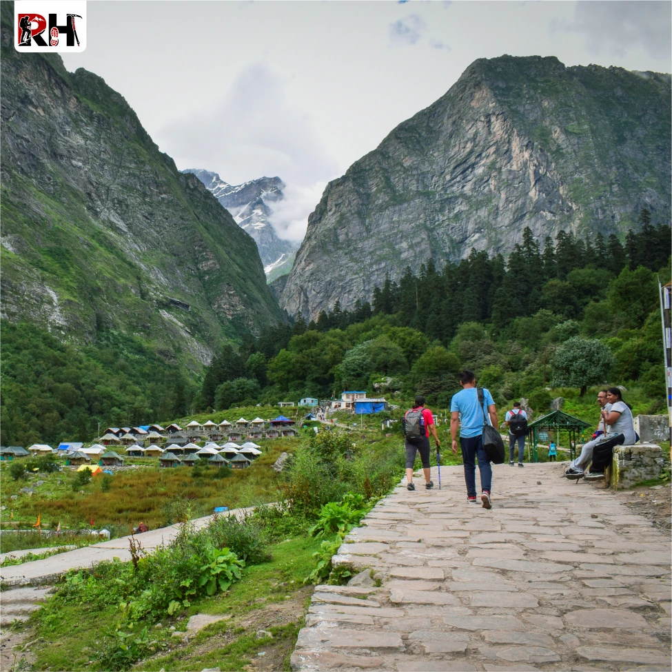
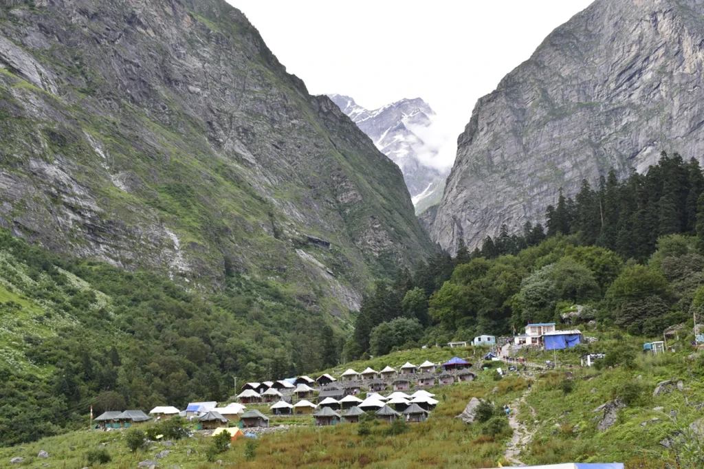
Ghangaria sits at about 3,000 metres and is the last village on this route, so you’ll spend the night here before both the Valley of Flowers and Hemkund Sahib treks the next two days.
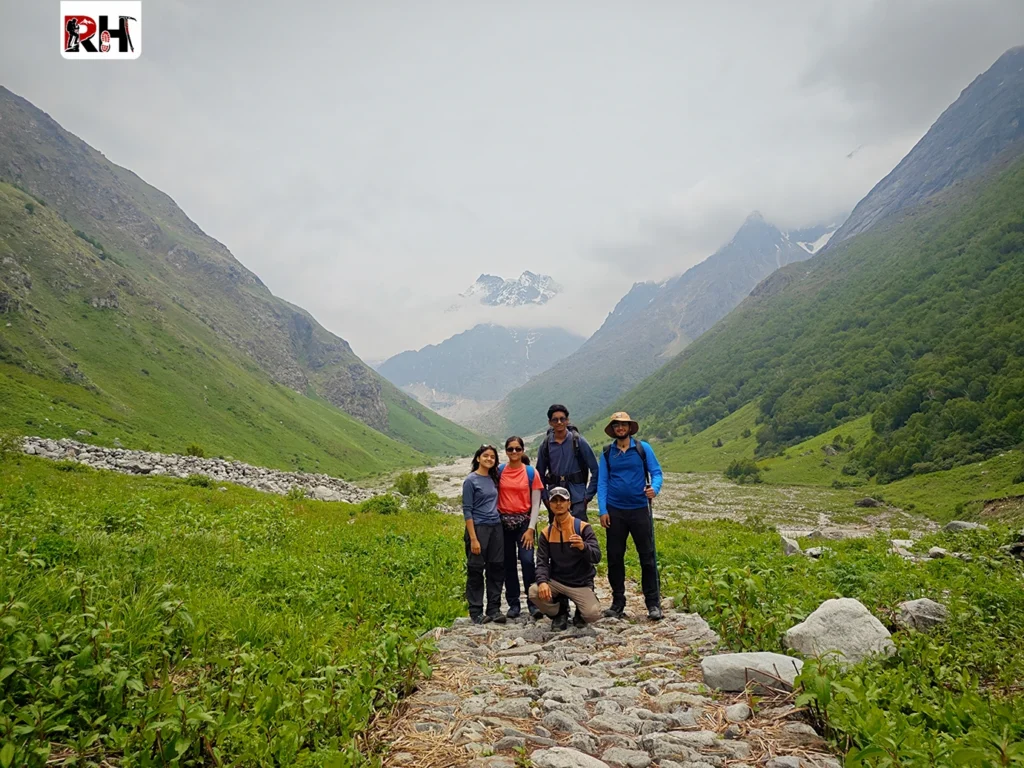
Day 3 – Ghangaria to Valley of Flowers and Back
Today is dedicated to the Valley of Flowers. After an early breakfast, you’ll trek about 6 km one way into the valley, collect your entry permit on the way, and spend a few hours exploring the flowers, streams, and mountain views.
You’ll trek back to Ghangaria by evening, covering roughly 12 km total for the day. This day requires steady walking but no technical difficulty, making it manageable even for careful beginners.
Day 4 – Ghangaria to Hemkund Sahib and Back
This is the toughest day of the whole trip. You’ll start very early, since the climb to Hemkund Sahib is steeper and covers around 6 km one way, gaining significant altitude to reach 4,329 metres.
After spending time at the Gurudwara and the lake, you’ll trek back down to Ghangaria the same day, completing about 12 km total. Starting early and pacing yourself matters a lot on this particular day.
Day 5 – Ghangaria to Govindghat, Badrinath & Mana Village
After breakfast, you’ll trek back down to Govindghat, covering the same 10 km from Day 2 in reverse. From Govindghat, you’ll then travel by vehicle to Badrinath Temple and nearby Mana Village.
This day mixes trekking with easy sightseeing, so while your legs are tired from the descent, the Badrinath visit itself requires no walking effort. You’ll stay overnight in Govindghat again.
Day 6 – Govindghat to Rishikesh
The final day is a long drive back to Rishikesh, retracing the same route from Day 1, taking around 10-11 hours. You’ll be dropped off in Rishikesh by evening, marking the end of your trek with plenty of memories and photos.
Valley of Flowers Entry Permit & Fees
To enter the Valley of Flowers National Park, every visitor needs an entry permit, issued right at the entry point near Ghangaria. The fee is ₹150 per person for Indian nationals and ₹600 per person for foreign nationals, and this permit stays valid for three days, so you can visit more than once if needed without paying again.
You’ll need to carry a valid ID proof to get this permit, and our trek coordinators help you complete this process quickly on Day 3 morning, so you don’t lose valuable exploring time standing in line.
How to book Valley of Flowers Trek Package?
Booking Valley of flowers trek with Roopkund Heaven is simple and takes just a few minutes online. Our current package starts from ₹8,200+ per person on triple sharing, based out of Govindghat, for the full 6 Days / 5 Nights trip, and includes your guide, meals, and stay.
Here’s how the booking process works, step by step:
Step 1 – Traveller Details: Enter your basic information needed to confirm your booking.
Step 2 – Trip Configuration: Choose your batch date, package type, and number of travellers joining you.
Step 3 – Rental Gear: Add any rental gear you need, like trekking poles or rain jackets — your total updates instantly as you add items.
Step 4 – Final Notes & Summary: Add any special notes, then review your full trek total, including trip cost, add-ons, rental gear, and GST (5%).
Once you’re happy with the summary, choose your payment plan through Razorpay — either Pay Full for instant confirmation, or Pay 30% Advance to reserve your seat now and clear the rest later. For example, on a base price of ₹8,200 with GST included, your full payable amount comes to ₹8,610. You can also apply a coupon code before payment if you have one. Once payment is done, your seat is confirmed immediately.
Package Inclusions & Exclusions
Knowing exactly what’s covered helps you plan your budget properly.
Included in the package:
Stay on a sharing basis at Govindghat and Ghangaria
All meals (breakfast and dinner) as per the itinerary
Experienced trek guide throughout the journey
Transport from Rishikesh to Govindghat and back
Not included in the package:
Valley of Flowers entry permit fee (₹150/₹600, paid separately)
Lunch and snacks during the trek
Personal expenses like laundry, tips, and shopping
Porter, pony, or helicopter charges (available at extra cost if needed)
Travel insurance and medical expenses
GST (5%), applied extra on the package price
What to Pack for Valley of Flowers Trek
Since this trek happens right in the middle of monsoon season, packing the right gear matters a lot for your comfort and safety. You’ll need proper rain protection, the right clothing, good trekking shoes, and a few extra essentials to handle wet, slippery trails.
Rather than repeating everything here, we’ve already written a complete, detailed guide covering exactly what to pack — check out our blog “What to Pack for a Monsoon Trek” for the full checklist, including rain gear, clothing tips, footwear advice, and health essentials specifically built for treks like this one.
Frequently Asked Questions
How many days are needed for Valley of Flowers, Hemkund Sahib & Badrinath?
This combined trip takes 6 days and 5 nights in total, starting and ending in Rishikesh. This includes travel days, two trekking days for Valley of Flowers and Hemkund Sahib, and a day for Badrinath and Mana Village.
Is the Hemkund Sahib trek difficult?
Yes, Hemkund Sahib is the toughest part of this trip, since it climbs higher and the path gets steeper near the top, reaching 4,329 metres. With some basic fitness preparation and an early start, most beginners complete it successfully.
Can senior citizens do this combined trek?
Yes, with proper planning. Senior citizens can use pony or porter services for the Govindghat-Ghangaria stretch and take things slow on trek days. We’d recommend consulting a doctor beforehand and going during clearer weather in September if possible.
What is the Valley of Flowers entry permit cost?
The entry permit costs ₹150 per person for Indian nationals and ₹600 per person for foreign nationals. This permit is valid for three consecutive days, so you don’t need to pay again if you visit more than once.
Is helicopter available for this trek?
Helicopter service is available for the Govindghat-Ghangaria stretch at an additional cost, though it’s not included in our standard package. Availability can be unpredictable during heavy rain, so we recommend keeping a backup plan.
Can I visit Badrinath without trekking?
Yes, Badrinath doesn’t require any trekking at all — a vehicle can take you right up to the temple. This is why it fits perfectly as a relaxed final stop after the more physically demanding Valley of Flowers and Hemkund Sahib treks.
How to Reach Valley of Flowers by Road
Road travel is unavoidable at some point in this journey regardless of how you start, so understanding your options here matters more than for almost any other leg.
Bus Services
Government and private buses operate regularly from Delhi, Haridwar, and Rishikesh to Joshimath, with onward transport available to Govindghat.
Delhi to Joshimath: Overnight buses available during the season.
Haridwar/Rishikesh to Joshimath: Regular Uttarakhand Roadways and private buses.
Joshimath to Govindghat: Shared taxis and local buses are easily available.
Buses are the most economical option, but the mountain journey is long and involves winding roads. If you’re prone to motion sickness, carrying medication is recommended.
Shared Taxi
Shared taxis are a popular and budget-friendly way to travel to Govindghat, especially for solo travellers and small groups. They are easily available from Rishikesh, Joshimath, and Govindghat during the trekking season.
Most shared taxis operate on a fill-and-depart basis rather than a fixed timetable, so you may need to wait until all seats are occupied before the vehicle leaves.
This option offers a good balance between cost and convenience, making it ideal for travellers who want a faster journey than a bus without paying for a private taxi. For the final stretch, shared taxis also run between Govindghat and Pulna, the last motorable village before the trek to Ghangaria begins.
City-Wise Route to Valley of Flowers
No matter which city you start from, every journey to the Valley of Flowers eventually follows the same Himalayan route through Haridwar or Rishikesh, Joshimath, Govindghat, Pulna, and Ghangaria. The only difference is how you reach Uttarakhand before beginning the mountain drive.
Delhi to Valley of Flowers
Delhi is the most popular starting point for the Valley of Flowers trek due to its excellent air, rail, and road connectivity. The usual route is Delhi → Haridwar/Rishikesh → Joshimath → Govindghat → Pulna → Ghangaria → Valley of Flowers. The road distance from Delhi to Govindghat is approximately 520–540 km, which takes around 12–14 hours of driving. Since the journey involves long mountain roads, most travellers divide it into two days by staying overnight in Haridwar, Rishikesh, or Joshimath. This makes the trip more comfortable and allows you to begin the trek feeling well-rested.
Bangalore to Valley of Flowers
Travellers from Bangalore are advised to fly to Dehradun or Delhi, as travelling entirely by train or road can take several days. After reaching Uttarakhand, the route continues through Rishikesh, Joshimath, Govindghat, Pulna, and Ghangaria before reaching the Valley of Flowers. Because the journey involves both flights and long mountain drives, it is a good idea to include an extra buffer day in your itinerary to accommodate possible flight delays or weather-related disruptions during the monsoon season.
Haridwar to Valley of Flowers
Haridwar serves as one of the main gateways to the Garhwal Himalayas. From here, the route passes through Rishikesh, Devprayag, Rudraprayag, Karnaprayag, Joshimath, Govindghat, Pulna, and Ghangaria before reaching the Valley of Flowers. The distance from Haridwar to Govindghat is approximately 290–300 km, and the drive usually takes 10–11 hours, depending on road conditions and traffic. Many travellers choose to stay overnight in Joshimath before continuing to Govindghat the following morning.
Rishikesh to Valley of Flowers
Rishikesh is one of the most convenient starting points for the Valley of Flowers trek. The route follows Rishikesh → Devprayag → Rudraprayag → Karnaprayag → Joshimath → Govindghat → Pulna → Ghangaria → Valley of Flowers. The road distance to Govindghat is around 270–280 km, and the journey generally takes 9–10 hours. From Rishikesh, travellers can easily find buses, shared taxis, and private cabs during the trekking season, making it a preferred departure point for many visitors.
Dehradun to Valley of Flowers
Dehradun is the nearest major city for travellers arriving by air. The route follows Dehradun → Rishikesh → Devprayag → Rudraprayag → Karnaprayag → Joshimath → Govindghat → Pulna → Ghangaria → Valley of Flowers. The road distance to Govindghat is approximately 290 km, with a travel time of around 9–10 hours. Since the route merges with the standard pilgrimage highway soon after leaving Dehradun, it is an ideal starting point for visitors flying into Uttarakhand before continuing their journey into the Himalayas.
Govindghat to Ghangaria – Your Travel Options
This is the stretch where the road genuinely ends, and choosing the right option here matters for both your comfort and your overall trek experience.
Trek from Govindghat to Ghangaria
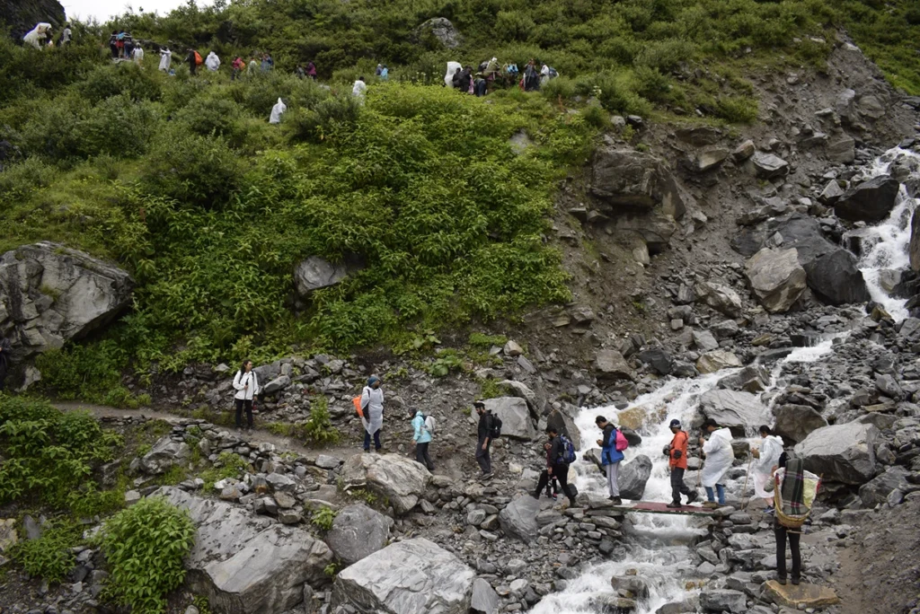
The trek from Pulna to Ghangaria covers approximately 9 km and usually takes 4 to 6 hours, depending on your pace and fitness level. The trail is well-maintained, clearly marked, and follows the scenic Pushpawati River through forests, waterfalls, and mountain landscapes. While it is suitable for beginners with a reasonable level of fitness, the continuous uphill climb can be physically demanding.
Starting the trek early in the morning is highly recommended, as it allows plenty of daylight and a more comfortable walking experience. Carrying only essential items in a small daypack will make the climb much easier.
Pony Service
Travellers who prefer not to walk can hire a pony from Govindghat or Pulna. The journey generally takes 3 to 4 hours and is a popular option for senior citizens, families with young children, and those who want to conserve energy for exploring the Valley of Flowers the following day.
Porter Service
If you would like to enjoy the trek without carrying heavy luggage, hiring a porter is an excellent option. Porters carry your backpack or duffel bag, allowing you to walk comfortably with only a light daypack. This is especially helpful for first-time trekkers and anyone carrying camping or photography equipment.
For elderly travellers or those with limited mobility, special carrier services (known locally as Kandi or Dandi) may also be available, subject to availability.
Helicopter Service
Helicopter services operate between Govindghat and Ghangaria, reducing the journey to just a few minutes. This is the fastest option and is particularly suitable for senior citizens or travellers who are unable to complete the trek. However, helicopter operations are completely weather-dependent and are often affected during the monsoon season due to poor visibility and rainfall. Because seats are limited, advance booking is highly recommended.
Need Extra Assistance? Roopkund Heaven Can Arrange It ⭐
If you are trekking with Roopkund Heaven, you can request pony services, porter services, helicopter assistance, or other trekking support at the time of booking your valley of flowers trek package. Our team will help arrange these services in advance, subject to availability, so you don’t have to search for them after reaching Govindghat.
Please note that these services are optional and are not included in the standard trek package. They are available at an additional cost, and the charges vary depending on the season and local government-approved rates. Booking them in advance helps ensure better availability, especially during the peak season.
Ghangaria to Valley of Flowers Trek
From Ghangaria, the final stretch into Valley of Flowers covers approximately 3-4 km one way, gaining meaningful altitude along a well-maintained but genuinely uphill trail. Trek distance and difficulty here shouldn’t be underestimated just because the numbers look small on paper — this stretch involves steady, sustained climbing, and combined with the altitude already gained at Ghangaria (around 3,000 metres), most trekkers find this more physically demanding than the Govindghat-to-Ghangaria leg despite covering less distance.
The entry gate to Valley of Flowers opens at 7:00 AM and typically requires visitors to exit by 5:00 PM, following strict forest department rules designed to protect the ecosystem and ensure visitor safety. Starting early, ideally reaching the gate right at opening time, gives you the most time to explore deeper into the valley rather than rushing a shortened visit.
Most trekkers spend a full day exploring, since the valley’s most striking, flower-dense areas sit further in rather than right at the entrance — a common mistake beginners make is turning back too early, assuming they’ve seen the highlights, when the truly spectacular sections require genuine walking time to reach. Plan for a full 6-8 hour round trip within the valley itself if you want to see it properly rather than just the outer edges.
Entry Permit, Fees & Timings
Valley of Flowers Entry Fees currently stand at approximately ₹150 for Indian nationals and ₹600 for foreign nationals, though these figures are worth reconfirming closer to your travel date since forest department fees can be revised. The Entry Permit Process is straightforward — permits are issued at the entry point in Ghangaria itself, requiring basic ID proof, and importantly, this permit remains valid for three consecutive days, meaning you don’t need to purchase a fresh one if you visit the valley across multiple days during your stay.
Opening & Closing Timings follow a consistent daily pattern — the gate opens at 7:00 AM and all visitors must exit by 5:00 PM, with no exceptions made for stragglers, since this timing exists specifically for visitor safety given how quickly weather and light conditions can change at this altitude.
Beyond daily timings, the park itself has a seasonal opening window, typically from around June 1st through October, depending on snow conditions and forest department assessment each year — visiting outside this window simply isn’t possible, so confirming current-year opening dates before finalising your travel plans is a genuinely essential step, not an optional check.
Road Conditions & Travel Tips
Current Road Conditions
The road from Rishikesh to Govindghat is generally in good condition, but heavy rainfall during the monsoon can cause temporary landslides and road closures, especially around Chamoli and Joshimath. Before starting your journey, it’s always a good idea to check the latest road conditions with your tour operator or local authorities.
Monsoon Travel Tips
The best time to see the Valley of Flowers in bloom—July and August—also coincides with the monsoon season. Expect occasional rain, slippery trails, and possible traffic delays due to landslides. Carry quality rain gear, waterproof your luggage, and keep a buffer day in your itinerary to accommodate weather-related delays.
Fuel, ATMs & Mobile Network
Joshimath is the last reliable town for fuel stations, ATMs, and essential supplies before Govindghat, so complete your cash withdrawals and refuelling there. Mobile connectivity is limited beyond Joshimath, with BSNL offering the best coverage. Network signals are weak in Ghangaria and almost unavailable inside the Valley of Flowers, so inform your family before beginning the trek.
Total Days Required to Reach & Explore Valley of Flowers
A 6-day itinerary is ideal for exploring the Valley of Flowers comfortably. It allows enough time for the long road journey, trekking, sightseeing, and gradual acclimatisation to the higher altitude. While it is possible to complete the trip in fewer days, doing so can be tiring and leaves little room for weather-related delays, which are common during the monsoon season.
Recommended 6-Day Itinerary
Day 1: Travel from Delhi to Haridwar or Rishikesh by train, bus, flight, or private taxi.
Day 2: Drive from Haridwar/Rishikesh to Govindghat via Devprayag, Rudraprayag, Karnaprayag, and Joshimath.
Day 3: Take a shared taxi to Pulna, then trek 9 km to Ghangaria, the base camp for the Valley of Flowers and Hemkund Sahib.
Day 4: Trek 4 km to the Valley of Flowers, spend the day exploring the national park, and return to Ghangaria by evening.
Day 5: Visit Hemkund Sahib (optional) or enjoy a second visit to the Valley of Flowers before trekking back to Pulna and driving to Govindghat.
Day 6: Drive back to Haridwar or Rishikesh and continue your onward journey.
This itinerary offers a comfortable pace, reduces travel fatigue, and provides enough flexibility to handle unexpected weather or road delays while making the most of your Valley of Flowers experience.
How to book Valley of Flowers Trek Package?
Booking this trek with Roopkund Heaven is simple and takes just a few minutes online. Our current package starts from ₹8,200+ per person on triple sharing, based out of Govindghat, for the full 6 Days / 5 Nights trip, and includes your guide, meals, and stay.
Here’s how the booking process works, step by step:
Step 1 – Traveller Details: Enter your basic information needed to confirm your booking.
Step 2 – Trip Configuration: Choose your batch date, package type, and number of travellers joining you.
Step 3 – Rental Gear: Add any rental gear you need, like trekking poles or rain jackets — your total updates instantly as you add items.
Step 4 – Final Notes & Summary: Add any special notes, then review your full trek total, including trip cost, add-ons, rental gear, and GST (5%).
Once you’re happy with the summary, choose your payment plan through Razorpay — either Pay Full for instant confirmation, or Pay 30% Advance to reserve your seat now and clear the rest later. For example, on a base price of ₹8,200 with GST included, your full payable amount comes to ₹8,610. You can also apply a coupon code before payment if you have one. Once payment is done, your seat is confirmed immediately.
Package Inclusions & Exclusions
Knowing exactly what’s covered helps you plan your budget properly.
Included in the package:
Stay on a sharing basis at Govindghat and Ghangaria
All meals (breakfast and dinner) as per the itinerary
Experienced trek guide throughout the journey
Transport from Rishikesh to Govindghat and back
Not included in the package:
Valley of Flowers entry permit fee (₹150/₹600, paid separately)
Lunch and snacks during the trek
Personal expenses like laundry, tips, and shopping
Porter, pony, or helicopter charges (available at extra cost if needed)
Travel insurance and medical expenses
GST (5%), applied extra on the package price
Frequently Asked Questions
How many days are needed to reach Valley of Flowers?
Reaching Valley of Flowers from Delhi typically takes 2-3 days of travel, including road journey and the Govindghat-Ghangaria trek. A complete trip with proper exploration and return journey needs a minimum of 5-6 days overall.
What is the nearest airport to Valley of Flowers?
Jolly Grant Airport in Dehradun is the nearest commercial airport, located roughly 270-300 km away by road. From there, you’ll still need to travel through Rishikesh and Joshimath before reaching Govindghat, the road’s endpoint.
What is the nearest railway station to Valley of Flowers?
Rishikesh and Haridwar are the two most commonly used railway stations, both located roughly 270-300 km from Valley of Flowers, with Haridwar offering somewhat better long-distance train connectivity across India.
Can I drive directly to Valley of Flowers?
No, you can only drive as far as Govindghat, roughly 17 km from the valley. Beyond Govindghat, the remaining distance must be covered by trekking, pony, porter, or helicopter, since no motorable road exists into the protected park.
Is helicopter service available for Ghangaria?
Yes, helicopter service operates between Govindghat and Ghangaria, though availability is unpredictable, especially during July and August when monsoon weather frequently causes delays or cancellations. Always have a backup plan if relying on this option.
Can senior citizens use pony or helicopter instead of trekking?
Yes, both pony and helicopter services are commonly used by senior citizens or travellers with mobility concerns to cover the Govindghat-Ghangaria stretch without trekking. Booking these in advance, rather than assuming same-day availability, is genuinely important during peak season.
Is the entry permit valid for multiple days?
Yes, the Valley of Flowers entry permit remains valid for three consecutive days from issue, meaning you don’t need a fresh permit if you visit the valley more than once during your stay in Ghangaria.
Is public transport available from Haridwar and Rishikesh?
Yes, regular buses and shared taxis operate from both Haridwar and Rishikesh toward Joshimath and Govindghat, offering a budget-friendly alternative to private taxis, though with less flexibility around timing and stops.
What is the best route to reach Valley of Flowers?
The most common and well-established route is Delhi/Haridwar/Rishikesh to Joshimath to Govindghat, followed by the trek to Ghangaria and onward to Valley of Flowers. This route has the best transport infrastructure and support services along the way.
Is the road to Govindghat open throughout the year?
The road generally stays open through the trekking season (roughly May to October), but conditions can be temporarily disrupted during heavy monsoon rain due to landslide risk. Valley of Flowers itself is only accessible during its seasonal opening window, typically June through October.
What to Pack for a Monsoon Trek: A Complete Guide by Roopkund Heaven
Monsoon trekking is an amazing experience, but the rain also brings muddy trails, slippery paths, and wet gear. Packing the right essentials can make your trek safer, more comfortable, and enjoyable.
In this guide, we’ll cover everything you need to pack for your monsoon trek , from rain gear and clothing to footwear, backpack essentials, and safety items. Whether you’re a beginner or an experienced trekker, this checklist will help you stay dry, comfortable, and well-prepared throughout your journey.
Why Monsoon Trekking Needs a Different Packing Approach
Monsoon trekking isn’t just “summer trekking with an umbrella” — it’s a genuinely different experience that demands a different kit altogether. Trails that are dusty and firm in April turn slippery and unpredictable in July, streams that are barely a trickle can swell into genuine crossings within hours, and the humidity means nothing you’re wearing dries quickly once it’s wet.
This is exactly why packing for a monsoon trek needs a fundamentally different mindset than packing for any other season. It’s not about bringing more gear — it’s about bringing gear specifically chosen to handle sustained wetness, sudden temperature drops, and terrain that behaves nothing like it does in dry months. A cotton t-shirt that’s perfectly fine in October becomes a genuine liability in August, staying damp and cold against your skin for hours instead of drying out.
At Roopkund Heaven, we’ve seen trekkers make the same mistake repeatedly — packing regular clothes and shoes that work well in dry weather, then being caught off guard when monsoon conditions hit differently than expected. Once you understand how monsoon conditions affect the trail, choosing the right gear becomes much easier, and that’s exactly what the rest of this guide walks you through.
How to Choose the Right Gear Based on Your Trekking Location
The gear you need for a monsoon trek depends on where you’re trekking. Different regions have different weather, trail conditions, and challenges, so it’s important to pack accordingly.
For Himalayan treks in Uttarakhand and Himachal Pradesh, such as the Valley of Flowers, Hampta Pass, or Kashmir treks, expect cool weather, higher altitudes, and occasional rain. Carry good rain protection, warm layers, waterproof trekking shoes, and quick-dry clothing to stay comfortable.
For Western Ghats treks in Maharashtra, Karnataka, or Kerala, heavy rainfall, muddy trails, and leeches are common. Along with rain gear, carry anti-leech socks, insect repellent, waterproof bags, and footwear with good grip.
If your trek goes above 3,000 metres, the weather can change quickly. Even during the monsoon, nights can be cold, so pack a fleece jacket, thermal layer, gloves, and a warm cap in addition to your rain gear.
Before you start packing, always check:
Expected weather and rainfall
Trek altitude and night temperatures
Trail conditions (muddy, rocky, or forest trails)
Trek duration and camping requirements
Packing according to your trekking location helps you stay comfortable, travel lighter, and enjoy the trek safely, no matter where you’re heading.
Rain Protection Essentials
Rain protection forms the backbone of any monsoon packing list, since everything else you carry depends on staying reasonably dry in the first place.
Poncho vs Rain Jacket – Which Should You Choose?
This is one of the most common questions trekkers ask is whether to carry a poncho or a rain jacket. The answer depends on the type of trek and how often you go trekking.
A poncho is a good choice for beginners. It covers both your body and your backpack, provides better airflow, and is an affordable option for short or easy treks. However, it can be difficult to manage on narrow trails or during strong winds.
A waterproof rain jacket is the better choice for regular trekkers and multi-day Himalayan treks. It offers a better fit, allows easier movement while climbing, and provides better protection in heavy rain and windy conditions. Pair it with waterproof rain pants for complete rain protection. Since a rain jacket doesn’t cover your backpack, you’ll also need a backpack rain cover.
Rain Cover for Your Backpack
A dedicated rain cover for your backpack isn’t optional — it’s one of those items that seems minor until the one time you skip it and open your bag at camp to find your sleeping bag and spare clothes soaked through. Most modern trekking backpacks include a built-in cover tucked into a bottom pocket, but if yours doesn’t, buying or renting one is genuinely worth the small cost.
Rain seeping into an uncovered backpack doesn’t just dampen your gear — it can ruin electronics, soak the one dry set of clothes you were saving for camp, and add significant weight from waterlogged fabric. A rain cover solves this simply and cheaply, and it’s one of the first things we check before any monsoon batch heads out.
Sun Cap Under Your Hood (Why It’s a Game-Changer)
It may seem odd to wear a sun cap, but it really works. When you’re wearing a rain jacket or poncho hood in steady rain, water constantly runs off the edge of the hood and drips straight onto your face. This can blur your vision and make it harder to see the trail ahead, especially on slippery or uneven sections.
Wearing a simple sun cap underneath your hood helps direct the water away from your face, keeping your line of sight clear. It’s a small, inexpensive addition that makes a big difference during long, rainy stretches. As a bonus, the same cap also protects you from the sun when the weather clears up.
Clothing for Monsoon Treks
What you wear directly against your skin matters just as much as your outer rain layer, since the wrong fabric choice can leave you cold and uncomfortable even under good rain protection.
Best Fabrics (Synthetic vs Cotton)
Synthetic fabrics like polyester, nylon, or moisture-wicking blends are the best choice for monsoon trekking. They dry much faster than cotton and don’t hold moisture against your skin for long. Cotton, on the other hand, absorbs water easily and takes a long time to dry. Once it’s wet, it usually stays wet—and cold—for most of the day.
This difference becomes obvious on the trail. A synthetic T-shirt that gets wet from sweat or rain starts drying quickly when the rain slows down. A cotton T-shirt stays damp, feels uncomfortable, and can make you feel cold, especially at higher altitudes or during windy weather.
What to Avoid Wearing
Jeans are one of the biggest mistakes beginners make on monsoon treks. They are already heavy, and once they get wet, they become even heavier, colder, and can take an entire day to dry. No matter how easy the trek looks, it’s best to leave your jeans at home.
Also avoid cotton innerwear and clothing that doesn’t stretch or breathe well. Monsoon trekking requires extra balance and movement on slippery trails, and tight or heavy clothing only makes the hike more tiring. Light-coloured cotton clothes also show mud and stains very easily, so darker, quick-dry fabrics are a much better option.
Packing Extra Dry Clothes
Always carry at least one complete spare set of clothes, including a T-shirt, trekking pants, and innerwear. Pack them separately in a waterproof dry bag or a sealed plastic bag so they stay completely dry throughout the trek.
Keep this backup set only for your campsite or overnight stay. Changing into clean, dry clothes after a long day of trekking in the rain makes a huge difference to your comfort and helps you stay warm.
Never pack your dry clothes together with wet ones. Even a little moisture can make them damp and defeat the purpose of carrying a spare set. We always tell our trekkers: pack your dry clothes like they’re the most precious thing in your bag, because by evening, they genuinely will be.
Footwear for Wet, Slippery Trails
Your feet face the toughest conditions during a monsoon trek, so choosing the right footwear is one of the most important decisions you can make
Waterproof vs Water-Resistant Trekking Shoes
Many people assume fully waterproof trekking shoes are the best option for monsoon treks. While they do keep water out for some time, they also trap heat and sweat inside, making your feet feel damp during long hours of walking. Water-resistant trekking shoes are often more breathable and comfortable for extended hikes.
However, here’s the reality of monsoon trekking: no matter which type of shoe you choose, your shoes will eventually get wet. Heavy rain, muddy trails, stream crossings, and water entering from the top make completely dry shoes almost impossible on a true monsoon trek.
Instead of focusing only on waterproofing, choose trekking shoes with:
Good ankle support
Deep, grippy soles for better traction on wet rocks and muddy trails
A snug yet comfortable fit
Most importantly, never wear brand-new trekking shoes on your trek. Break them in at least a few weeks before your trip. Wet conditions combined with new shoes can quickly cause painful blisters, turning an enjoyable trek into an uncomfortable experience.
Waterproof Socks
Waterproof socks are one of the most useful gear items for monsoon trekking, yet many beginners don’t discover them until after their first rainy trek. They are made with a three-layer design—a durable outer layer, a waterproof membrane in the middle, and a soft inner lining—that helps keep your feet dry even when your trekking shoes become wet.
Since wet feet are almost unavoidable during monsoon treks, carrying at least one good pair of waterproof socks can make a big difference in comfort. They are especially helpful on multi-day treks, where constantly damp feet can lead to blisters, cold feet, and overall discomfort. A quality pair of waterproof socks helps keep your feet warmer, drier, and more comfortable throughout the journey.
Additional Footwear – Clogs or Sandals for Camp
Carry a lightweight pair of clogs or sandals for use at the campsite. They may seem like an extra item to pack, but after spending the day in wet trekking shoes, changing into dry, comfortable footwear gives your feet a chance to rest and recover.
They are also useful during stream crossings, allowing you to avoid walking barefoot over slippery rocks or hidden sharp stones.
To save space inside your backpack, clip your clogs or sandals to the outside of your bag instead of packing them inside. This keeps your main compartment free for gear that needs to stay dry.
Anti-Leech Socks
If your trek passes through leech-prone areas—such as the Western Ghats or lower-altitude Himalayan forests—anti-leech socks are highly recommended. They are made from thick, tightly woven material and are worn over your trekking pants and inside your shoes, helping prevent leeches from reaching your skin.
For many trekkers, especially first-timers, anti-leech socks provide extra confidence on wet forest trails. When combined with full-length pants and avoiding shorts, they offer excellent protection and let you enjoy the trek without constantly worrying about leeches.
Waterproofing Your Backpack and Belongings
A backpack rain cover protects your bag from direct rainfall, but it’s not enough on its own. During heavy rain, water can still seep inside through zippers, seams, or when you open your backpack. That’s why it’s important to protect your belongings from the inside as well.
Dry Sacks & Waterproof Bags
Dry sacks are waterproof bags that go inside your backpack to keep your essential gear completely dry. Use them to store items such as warm clothes, thermals, spare clothing, sleeping wear, and anything else you can’t afford to get wet.
If you don’t want to buy dry sacks, sturdy plastic bags or ziplock bags are a simple and affordable alternative. Pack your belongings in separate bags before placing them inside your backpack. This easy “jugaad” method has been used by trekkers for years and works surprisingly well.
Protecting Electronics and Gadgets
Your phone, camera, power bank, and other electronic devices should always be packed in waterproof pouches or dry bags. Even a short period of heavy rain can damage electronics if they aren’t properly protected.
If you plan to use your phone for photos or navigation during the trek, consider using a waterproof phone case. It’s also a good idea to keep a few silica gel packets inside your electronics pouch. They help absorb moisture and reduce the risk of humidity damaging devices, especially cameras and camera lenses.
Protecting Documents, ID & Cash
Keep your ID cards, permits, cash, and other important documents in a separate waterproof pouch or ziplock bag. On many Himalayan treks, you’ll need to show your ID or permits at registration points or checkpoints. Wet or damaged documents can create unnecessary problems.
Store this pouch in an easy-to-reach pocket of your backpack so you can access it quickly without unpacking your entire bag. It’s a small habit that can save you a lot of hassle during your trek.
Camping & Trekking Accessories
Beyond clothing and rain gear, a handful of accessories make a genuine difference to comfort and safety on monsoon treks specifically.
Trekking Poles
Trekking poles are one of the most useful accessories for monsoon trekking. Wet rocks, muddy trails, and slippery descents increase the risk of slipping, and trekking poles provide extra balance and stability. They also reduce pressure on your knees, especially while walking downhill.
For beginners, trekking poles help build confidence by allowing you to test the ground before taking a step. On difficult sections, they act as extra points of support and can significantly reduce the chances of falls.
Headlamp/Flashlight & Power Bank
Power cuts are common during the monsoon, especially at remote campsites and homestays. A waterproof or water-resistant headlamp is a much better choice than a regular flashlight because it keeps your hands free while walking around camp, setting up your tent, or handling tasks after sunset.
A power bank is equally important. Rainy weather and remote locations often mean limited charging opportunities, and your phone is essential for navigation, communication, emergency contact, and taking photos. Keep both your power bank and charging cables inside a waterproof pouch to protect them from moisture.
Thermal Flask & Quick-Dry Towel
A thermal flask filled with hot water, tea, or coffee can be incredibly comforting after hours of trekking in cold rain. It helps you stay warm and hydrated without needing to stop and prepare a hot drink.
A quick-dry microfiber towel is another must-have. Unlike regular cotton towels, it dries much faster, weighs less, and doesn’t stay damp for days. It also takes up very little space in your backpack, making it ideal for multi-day treks.
Sleeping Bag & Waterproof Tent (If Camping)
If your trek includes camping, carry a sleeping bag suitable for the expected temperatures. Store it in a waterproof dry sack so it stays completely dry. Even a high-quality sleeping bag loses much of its warmth if it becomes wet.
Your tent should also be designed for rainy conditions. Choose a waterproof tent with sealed seams and a good-quality rainfly to prevent water from leaking inside during heavy rain. Before your trek, always check that your tent is in good condition and fully waterproof to avoid an uncomfortable night in the mountains.
Health & Insect Protection
Monsoon conditions bring specific health considerations that dry-season treks simply don’t require you to think about as carefully.
Basic First Aid Kit
Your monsoon trek first aid kit should include the basics — cotton, antiseptic cream, band-aids, and any personal medication — but with a few monsoon-specific additions like antifungal cream for feet that stay damp for extended periods, and rehydration salts in case of any stomach upset from questionable water sources along remote routes.
Blisters and minor cuts, common enough in any season, become more prone to infection in constantly damp, muddy conditions, so treating even minor injuries promptly rather than waiting until camp genuinely matters more during monsoon than dry-season trekking.
Mosquito & Leech Repellents
Mosquitoes and leeches are much more common during the monsoon, especially on forest trails. Carry a good insect repellent and apply it to exposed skin before starting your trek. Reapply it during the day, as rain and sweat can reduce its effectiveness.
For leech-prone areas, combine insect repellent with full-length clothing, proper trekking shoes, and anti-leech socks for the best protection.
Waterproof Gloves (Cold-Weather Protection)
Waterproof gloves are often overlooked but can be extremely useful on high-altitude monsoon treks. Rain, wind, and cold temperatures can quickly make your hands numb, making it difficult to hold trekking poles, adjust your backpack, or use your phone.
If you’re trekking above 3,000–3,500 metres, such as on the Valley of Flowers Trek or other Himalayan routes, waterproof insulated gloves are well worth carrying. They keep your hands warm, dry, and comfortable even in cold, rainy conditions.
Common Monsoon Trekking Mistakes to Avoid
Most problems people face on monsoon treks are caused by a few common mistakes that are easy to avoid with the right preparation.
One of the biggest mistakes is overpacking unnecessary items while forgetting important essentials like a backpack rain cover, dry sacks, waterproof socks, or a spare set of dry clothes. Pack only what you truly need and make sure every item has a clear purpose.
Here are some of the most common monsoon trekking mistakes:
Wearing jeans or cotton clothing, which stays wet for hours and can make you feel cold and uncomfortable.
Wearing new trekking shoes without breaking them in first, increasing the risk of painful blisters.
Underestimating how slippery monsoon trails can be and skipping trekking poles for extra balance.
Packing wet and dry clothes together instead of keeping spare clothes in waterproof bags.
Leaving phones, cameras, power banks, and important documents without proper waterproof protection.
Ignoring mosquito or leech protection on forest trails where insects are common.
Carrying too much weight, making it harder to walk on muddy and slippery terrain.
A little planning goes a long way. Packing the right gear, keeping your essentials dry, and preparing for wet trail conditions will make your monsoon trek safer, more comfortable, and much more enjoyable.
Pro Tips for a Comfortable Monsoon Trek
A few simple habits can make your monsoon trek much more comfortable and enjoyable.
Keep your rain jacket, poncho, and backpack rain cover at the top of your backpack so you can reach them quickly. In the Himalayas, rain often starts suddenly, especially during the afternoon, and you don’t want to unpack your entire bag when the weather changes.
As soon as you reach your campsite or homestay, change into a dry set of clothes. Staying in wet clothes for too long can make you feel cold and uncomfortable, especially in the evening.
Walk at a steady pace and don’t rush. Monsoon trails are muddy, slippery, and more tiring than they appear. Taking smaller, careful steps and using trekking poles will help you stay balanced and conserve energy throughout the day.
Drink plenty of water and eat regular snacks to maintain your energy levels, even if the cool weather makes you feel less thirsty.
Most importantly, go with the right mindset. On a monsoon trek, getting wet is part of the experience. Trails may take longer than expected, weather can change quickly, and plans may need to be adjusted for safety. If you stay flexible and enjoy the lush green landscapes, waterfalls, misty forests, and peaceful atmosphere that the monsoon brings, you’ll likely find it to be one of the most memorable trekking experiences.
Frequently Asked Questions
Is a poncho or rain jacket better for trekking?
Both work well, but the better choice depends on your trek. A poncho is a good option for beginners and occasional trekkers because it covers both you and your backpack while providing better airflow. A rain jacket with rain pants offers better freedom of movement and is more comfortable on challenging or multi-day treks. If you choose a rain jacket, don’t forget to carry a separate backpack rain cover.
How do I keep my backpack dry during a monsoon trek?
Use a backpack rain cover to protect the outside of your bag. Inside your backpack, pack important items like clothes, electronics, and sleeping gear in dry sacks or waterproof plastic bags. This double layer of protection keeps your belongings dry even during heavy rain.
What shoes are best for monsoon trekking?
Choose trekking shoes with good ankle support, deep-grip soles, and a comfortable fit. Whether you choose waterproof or water-resistant shoes, they are likely to get wet during a heavy monsoon trek. Pairing your shoes with waterproof socks helps keep your feet more comfortable and reduces the chances of blisters.
How do I protect my phone and camera from rain?
Keep your phone, camera, power bank, and other electronics inside a waterproof pouch or dry bag. If you plan to use your phone while it’s raining, a waterproof phone case is a worthwhile investment. You can also place a few silica gel packets inside the pouch to absorb moisture and protect your devices from humidity.
How do I avoid leeches while trekking?
If you’re trekking in leech-prone areas, wear anti-leech socks, full-length trekking pants, and proper trekking shoes. Avoid wearing shorts, and apply insect repellent to exposed skin. Together, these simple precautions greatly reduce the chances of leech bites and let you enjoy the trek with confidence.
Meet the Himalayan Flowers That Bloom Only for a Few Weeks
A Complete Guide to the Magical Wildflowers of the Valley of Flowers
The Himalayas are breathtaking in every season. Snow-covered peaks during winter, lush forests in spring, crystal-clear rivers in summer, and golden landscapes in autumn each have their own charm.
Yet, for just a few magical weeks during the monsoon, one destination transforms into something extraordinary—a vibrant alpine paradise filled with thousands of blooming wildflowers.
Welcome to the Valley of Flowers Trek, one of India’s most spectacular Himalayan experiences.
Unlike botanical gardens, where flowers bloom throughout the year with human care, the Valley of Flowers follows nature’s own rhythm. Most flowers bloom only for a brief period between July and early September, completing their entire life cycle within a few weeks before disappearing until the following year.
This fleeting beauty is exactly what makes the valley so special.
Every visit is different. Every season tells a new story.
The Valley of Flowers – Nature’s Living Canvas
Nestled in the Chamoli district of Uttarakhand, the Valley of Flowers National Park sits at an altitude of approximately 3,658 meters (12,000 ft) and forms part of the UNESCO World Heritage Site within the Nanda Devi Biosphere Reserve.
Covering nearly 87 square kilometers, the valley is home to more than 500 species of alpine flowers, along with rare birds, butterflies, medicinal plants, and Himalayan wildlife.
During the monsoon, melting snow and regular rainfall awaken the alpine meadows, turning the valley into a colorful carpet unlike anywhere else in the Himalayas.
The landscape constantly changes throughout the blooming season.
Flowers visible in early July may completely disappear by August, replaced by entirely different species.
Nature follows its own calendar.
Why Do These Himalayan Flowers Bloom for Such a Short Time?
Life at high altitude is challenging.
The Himalayan growing season is extremely short because:
Snow covers the region for nearly eight months.
Temperatures remain below freezing for much of the year.
Plants have only a few weeks of favorable weather.
They must germinate, bloom, attract pollinators, produce seeds, and complete their life cycle before winter returns.
This remarkable adaptation is what creates the valley’s spectacular but short-lived floral display.
Meet the Himalayan Flowers That Bloom Only for a Few Weeks
1. Brahma Kamal (Saussurea obvallata)
Perhaps the most sacred flower in the Indian Himalayas, Brahma Kamal is Uttarakhand’s State Flower.
Although many visitors associate it with the Valley of Flowers, it is actually found at higher elevations, especially around Hemkund Sahib, which many trekkers visit after completing the Valley of Flowers Trek.
The flower blooms during the monsoon and is revered in local traditions and Hindu mythology.
Interesting fact: It often blooms at night and survives in some of the harshest alpine conditions.
2. Himalayan Blue Poppy
One of the most sought-after flowers in the Himalayas, the Blue Poppy captivates visitors with its delicate sky-blue petals.
It thrives in cool alpine meadows and is considered one of the rarest flowering plants found in the higher Himalayan ecosystem.
Its brilliant color creates an unforgettable contrast against the surrounding green landscape.
3. Cobra Lily
The Cobra Lily is among the most fascinating wildflowers found in the valley.
Its unusual hood-shaped structure resembles a cobra ready to strike, giving it its distinctive name.
Despite its dramatic appearance, it plays an important ecological role within the alpine ecosystem.
4. Primulas
Primulas are among the first flowers to welcome trekkers entering the valley.
These charming blossoms appear in shades of:
Pink
Purple
Yellow
White
Lavender
Their colorful clusters brighten the meadows and create some of the valley’s most photogenic landscapes.
5. Himalayan Anemones
Graceful and elegant, Himalayan Anemones gently sway with the mountain breeze.
Their soft petals and delicate stems add movement and beauty to the already vibrant alpine meadows.
These flowers are often seen alongside streams and grassy slopes.
6. Potentillas
Potentillas cover large sections of the valley floor with cheerful yellow blossoms.
Although individually small, they create vast golden patches that blend beautifully with surrounding purple and pink flowers.
They are among the most widespread flowering species during peak bloom.
7. Himalayan Geraniums
Purple and pink Himalayan Geraniums are commonly seen throughout the trekking trail.
Their vibrant colors attract butterflies and pollinating insects, making them an essential part of the valley’s fragile ecosystem.
They often bloom in dense clusters, adding even more richness to the landscape.
More Than Just Seven Flowers
These famous flowers represent only a small part of the valley’s incredible biodiversity.
The Valley of Flowers is home to hundreds of flowering plants, including:
Marsh Marigolds
Himalayan Bellflowers
Bistort
Pedicularis
Daisies
Orchids
Buttercups
Delphiniums
Campanulas
Ligularias
Together, they create one of the richest high-altitude floral ecosystems anywhere in the world.
Every Week Looks Different
One of the most fascinating aspects of the Valley of Flowers Trek is how quickly the landscape changes.
Early July
Snow begins melting.
Fresh greenery emerges.
Early bloomers start appearing.
Mid July
Meadows become increasingly colorful.
Primulas and early alpine flowers dominate.
Late July
Peak flowering season.
Maximum variety of species.
Ideal photography conditions.
August
New flowers replace earlier blooms.
Different shades and floral patterns emerge.
Early September
Flowers gradually fade.
Meadows prepare for winter.
Grasses turn golden before snowfall returns.
This ever-changing cycle ensures that no two visits are exactly alike.
Responsible Trekking Matters
The flowers of the Himalayas survive only because this fragile ecosystem has remained largely undisturbed.
As trekkers, photographers, and nature lovers, we all share the responsibility of protecting it.
While visiting the Valley of Flowers, always remember:
Never pick wildflowers.
Stay on designated trekking trails.
Avoid stepping into flower beds for photographs.
Carry back all plastic and waste.
Respect wildlife and local biodiversity.
Avoid making loud noises.
Leave the valley exactly as you found it.
Small actions by every visitor help preserve this incredible landscape for future generations.
Other Himalayan Treks That Nature Lovers Should Explore
If alpine meadows, mountain flowers, and Himalayan landscapes fascinate you, there are several other unforgettable treks in Uttarakhand besides the Valley of Flowers Trek.
Ali Bedni Bugyal Trek
The Ali Bedni Bugyal Trek is famous for its endless rolling meadows, panoramic Himalayan views, ancient temples, and vibrant grasslands that come alive during the monsoon.
Roopkund Trek
The legendary Roopkund Trek combines alpine meadows, mysterious history, glacial landscapes, and spectacular mountain scenery, making it one of Uttarakhand’s most iconic high-altitude adventures.
Brahmatal Trek
Although renowned as a winter trek, the Brahmatal Trek also showcases beautiful alpine vegetation, pristine forests, and breathtaking Himalayan views during the warmer months.
Kuari Pass Trek
The Kuari Pass Trek offers dense oak forests, rhododendron trails, open bugyals, and panoramic views of towering Himalayan peaks, making it one of the most scenic moderate treks in Uttarakhand.
Conclusion
Some of nature’s greatest wonders exist only for a short time.
The flowers of the Himalayas remind us that beauty does not have to last forever to leave a lasting impression.
For just a few weeks every year, the Valley of Flowers becomes one of the world’s most extraordinary natural spectacles—a place where every bloom has a purpose, every meadow tells a story, and every responsible trekker plays a role in preserving it.
Whether you’re planning the Valley of Flowers Trek, exploring the Ali Bedni Bugyal Trek, dreaming about the Roopkund Trek, enjoying the scenic Kuari Pass Trek, or experiencing the beauty of the Brahmatal Trek, remember that these fragile Himalayan ecosystems deserve our respect as much as our admiration.
Because every flower in the Himalayas has a story.
And every responsible trekker helps protect that story for generations to come.
Adi Kailash Yatra Suspended Till Monsoon
If you’re planning the Adi Kailash Yatra and have heard that the pilgrimage has been suspended, it’s natural to have questions. Due to heavy monsoon rainfall in the Pithoragarh region, the local administration has temporarily stopped the yatra and suspended the issuance of Inner Line Permits (ILPs) for the safety of pilgrims.
In this guide, we explain why the yatra has been paused, which routes are affected, when it is likely to resume, and what you should do if you have already booked your trip. This simple guide will help you stay informed and plan your journey with confidence.
Adi Kailash Yatra Suspended – Latest Official Update
The Adi Kailash Yatra has been temporarily suspended by the Pithoragarh district administration due to continuous heavy rainfall and unsafe road conditions. This is an official announcement, not a rumour, and it applies to all pilgrims planning to visit Adi Kailash.
The suspension was announced after heavy monsoon rains caused landslides, falling rocks, road damage, and debris at several points along the route. Since the Adi Kailash Yatra passes through remote Himalayan roads near the India–China border, even a small landslide can block the only access road and create serious safety risks. To protect pilgrims, the administration has temporarily stopped all yatra activities until conditions improve.
The July and August monsoon season is one of the most challenging periods for travel in this region. Continuous rainfall can quickly weaken mountain slopes, leading to road closures, flash floods, and unexpected landslides. This is why authorities closely monitor weather conditions and suspend the yatra whenever passenger safety is at risk.
If you have planned your journey with Roopkund Heaven or are travelling independently, we strongly recommend not starting your trip until the administration officially announces that the route is safe to reopen. The suspension also affects travel schedules, Inner Line Permits, and vehicle movement, so waiting for official clearance is the safest option.
Inner Line Permit (ILP) Suspension – Everything You Need to Know
The Inner Line Permit (ILP) is mandatory for visiting Adi Kailash because the route passes through a sensitive border area near the India–China border. Without a valid ILP, no pilgrim is allowed to enter the yatra route.
Due to the temporary suspension of the Adi Kailash Yatra, the administration has also stopped issuing new Inner Line Permits. The suspension came into effect in early July 2026 after continuous heavy rainfall, landslides, and road damage made the route unsafe for travel.
The administration has paused new permits to prevent more pilgrims from entering a region where road conditions are unstable and rescue operations can become difficult. By stopping ILP issuance, authorities can better manage the number of people already on the route and reduce the risk of anyone getting stranded due to landslides or road closures.
If you already have a booking for the Adi Kailash Yatra, please note that a previous booking does not guarantee entry. Without an active and valid Inner Line Permit, pilgrims will not be allowed to cross the security checkpoints.
We are following official updates regarding ILP issuance. As soon as the administration resumes issuing permits and declares the route safe, we will help our guests complete the permit process and update them with the latest travel information.
Official Statement from the Pithoragarh District Administration
The Pithoragarh district administration has issued an official advisory regarding the temporary suspension of the Adi Kailash Yatra. The administration has asked all pilgrims to avoid travelling on the Adi Kailash route until further notice due to unsafe road conditions caused by heavy rainfall and landslides. Security checkpoints are also ensuring that no one enters the restricted route without permission.
Officials have acknowledged that the suspension may affect the travel plans of many pilgrims and have expressed regret for the inconvenience. However, they have emphasized that the safety of pilgrims is the highest priority, and the yatra will resume only after the roads are declared safe.
The administration has also instructed all tour operators to stop new departures on the affected route and to provide accurate information to travellers instead of making uncertain promises about reopening dates.
Pilgrims are advised to follow only official updates from the district administration, Uttarakhand Government, and the India Meteorological Department (IMD). Avoid relying on unverified social media posts or forwarded messages, as they may contain outdated or incorrect information.
Landslide-Prone Areas Along the Adi Kailash Route
Not every part of the route is equally affected, and knowing exactly where the real risk lies helps you understand this situation instead of assuming the entire region is a disaster zone.
Dharchula to Tawaghat Road Conditions
One of the most vulnerable sections is the Dharchula–Tawaghat road. Heavy rain has caused landslides, falling debris, and road damage in this area, making it unsafe for vehicles. Since this is the main route to Adi Kailash, any blockage here can temporarily stop the entire yatra.
Mangti and Other High-Risk Zones
Another high-risk area is Mangti, along with a few nearby stretches. During the monsoon, continuous rain weakens the mountain slopes, increasing the chances of fresh landslides and road closures. Even if a road appears open, conditions can change quickly due to falling rocks or sudden slope failure.
The district administration and road maintenance teams are working to clear debris and restore the roads. However, repair work depends on weather conditions, and heavy rain can delay restoration efforts.
India Meteorological Department (IMD) Weather Alert
The India Meteorological Department (IMD) has issued Yellow and Orange weather alerts for Pithoragarh and nearby districts due to continuous heavy rainfall during the first week of July. An Orange Alert indicates the possibility of heavy rain, landslides, road blockages, and travel disruptions, making conditions unsafe for pilgrims.
Based on these weather warnings and the ground situation, the district administration temporarily suspended the Adi Kailash Yatra to ensure the safety of all travellers.
According to the latest forecasts, intermittent heavy rainfall is expected to continue, and weather conditions may remain unstable for the next few days. The administration is expected to resume the yatra only after rainfall decreases, roads are restored, and the route is declared safe.
How Many Pilgrims Have Completed the Adi Kailash Yatra So Far?
Before the temporary suspension, the 2026 Adi Kailash Yatra was witnessing an excellent response from pilgrims across India.
Since the yatra opened on 1 May 2026, the administration has issued more than 52,441 Inner Line Permits (ILPs) for the Adi Kailash and Om Parvat routes, making it one of the busiest pilgrimage seasons in recent years. Most pilgrims completed their journey successfully during May and June, when weather conditions remained favourable and roads were largely accessible.
The current suspension is mainly due to the July–August monsoon season, when heavy rainfall increases the risk of landslides, road closures, and flash floods in the Himalayan region. This is a normal weather pattern, and every year the administration closely monitors conditions before allowing pilgrims to travel.
If weather conditions improve as expected, the Adi Kailash Yatra is likely to resume from September and continue through October, which is considered one of the best times to visit Adi Kailash. During these months, the skies are usually clearer, the mountain views are spectacular, and road conditions are much more stable than during the monsoon.
Plan Your September–October Adi Kailash Yatra
If you’re planning to visit Adi Kailash after the monsoon, we recommend booking your September or October departure in advance. These months are in high demand, and permits, accommodation, and transport fill up quickly once the yatra reopens.
At Roopkund Heaven, we have already started accepting advance bookings for the September–October 2026 Adi Kailash Yatra. Once the administration officially resumes the yatra, our team will handle your Inner Line Permit, accommodation, transportation, and complete travel arrangements, ensuring a safe and hassle-free pilgrimage.
About Adi Kailash and Om Parvat
Adi Kailash and Om Parvat are two of the most sacred destinations in Uttarakhand, attracting thousands of pilgrims and nature lovers every year. Located in the Pithoragarh district near the India–China border, both places are known for their religious importance and breathtaking Himalayan scenery.
Adi Kailash (Chhota Kailash)
Adi Kailash, also known as Chhota Kailash, is believed to be the earthly abode of Lord Shiva and is considered a sacred counterpart to Mount Kailash in Tibet. The mountain stands near Jolingkong, where pilgrims also visit the holy Parvati Sarovar. Surrounded by snow-capped peaks and peaceful landscapes, Adi Kailash offers a unique spiritual experience in the Himalayas.
Om Parvat
Om Parvat is famous for the naturally formed “Om (ॐ)” symbol that appears on its snow-covered face. This rare natural phenomenon makes it one of the most revered mountains in India. Pilgrims usually visit Adi Kailash and Om Parvat together as part of the same yatra.
Location Near the India–China Border
Both Adi Kailash and Om Parvat are located close to the India–China border, which is why an Inner Line Permit (ILP) is mandatory for all visitors. The route passes through security checkpoints, and every traveller must carry valid documents and permits throughout the journey.
Spiritual Significance
The Adi Kailash Yatra is often considered a spiritual alternative to the Kailash Mansarovar Yatra. While Mount Kailash lies in Tibet, Adi Kailash allows devotees to experience a similar spiritual atmosphere without leaving India. Every year, thousands of pilgrims visit this sacred region to seek the blessings of Lord Shiva and enjoy the peaceful beauty of the Himalayas.
When Will the Adi Kailash Yatra Resume?
Based on previous years, the Adi Kailash Yatra is expected to reopen from September 2026, after the monsoon season. September and October are considered the best months to visit Adi Kailash, as the weather is pleasant, the skies are clearer, and road conditions are generally much safer.
If you are planning your pilgrimage after the monsoon, we recommend booking your September or October departure in advance, as Inner Line Permits (ILPs), accommodation, and transport get booked quickly once the yatra resumes.
Already Booked Your Adi Kailash Yatra with Roopkund Heaven?
If your travel dates fall during the suspension period, there’s no need to worry. Our team is here to assist you throughout the process.
Frequently Asked Questions (FAQs)
Is the Adi Kailash Yatra currently closed?
Yes. The Adi Kailash Yatra is temporarily suspended due to heavy monsoon rainfall, landslides, and unsafe road conditions in Pithoragarh district. The yatra will resume only after the administration declares the route safe.
When is the Adi Kailash Yatra expected to reopen?
There is no official reopening date yet. However, if weather conditions improve, the yatra is expected to resume from September 2026. September and October are considered the best months to visit Adi Kailash.
Are Inner Line Permits (ILPs) being issued?
No. New Inner Line Permits (ILPs) are currently on hold due to the suspension. Permit issuance will restart once the administration officially reopens the yatra.
What is the difference between Adi Kailash and Om Parvat?
Adi Kailash is a sacred mountain near Jolingkong, revered as the earthly abode of Lord Shiva. Om Parvat is a nearby peak famous for the naturally formed “Om (ॐ)” symbol created by snow on its face. Most pilgrims visit both destinations during the same journey.
What happens if I have already booked my Adi Kailash Yatra?
If you have booked with Roopkund Heaven, our team will help you reschedule your trip, assist with updated ILP arrangements, and provide the latest official travel updates. Refunds or cancellations are handled according to the booking terms and conditions.
Can I visit Om Parvat during the suspension?
No. Since Om Parvat and Adi Kailash share the same route and permit system, both destinations remain closed until the administration lifts the suspension.
Which is the best time to visit Adi Kailash?
The best time to visit is May to June and September to October. For post-monsoon travel, September and October offer pleasant weather, clear mountain views, and safer road conditions.
Where can I get the latest Adi Kailash Yatra updates?
You can follow updates from the Pithoragarh District Administration, Uttarakhand Government, and the India Meteorological Department (IMD). You can also contact Roopkund Heaven, and our team will keep you informed about the latest road conditions, permit status, and reopening announcements.
Why Trekking to Adi Kailash Is More Than Just a Hike – Culture, Myth & Himalayan Majesty
In the vast, sprawling network of Himalayan trails, few hold the sanctity, history, and raw natural grandeur of the route leading to Adi Kailash. Often overshadowed by its colossal namesake in Tibet, the Adi Kailash trek also known as Chhota Kailash or the Shiva Parvati abode is not merely a test of endurance; it is a profound pilgrimage (yatra) that weaves together spirituality, ancient culture, and some of the most breathtaking mountain scenery in the world.
To undertake this journey is to travel through time, tracing the footsteps of sages, explorers, and devotees.This long form guide reveals why trekking to Adi Kailash offers a transformative experience that transcends the definition of a simple hike.
The Pillar of Myth and Spirituality: A Journey to the Sacred
The primary distinction of the Adi Kailash trek is its profound spiritual resonance. It is a journey to a mountain revered by millions, making it a sacred obligation rather than a recreational choice for many.
The Mythological Significance
Adi Kailash is recognized as the original abode of Shiva and Parvati in the Indian Puranas, predating the current narrative surrounding the larger Mount Kailash.
Chhota Kailash: The peak itself, though smaller than the Tibetan Kailash, mirrors its pyramidal structure and holds immense symbolic power.Its proximity to the sacred Parvati Sarovar (Parvati Lake) and Gauri Kund signifies the eternal union of the divine couple, Shiva and Parvati.
The Om Parvat: The trek includes a detour to witness the spectacular Om Parvat (or Little Kailash), a mountain where the deposition of snow and the outline of the peak naturally form the sacred symbol ‘ॐ’ (Om).This visible divine manifestation is a source of awe and deep spiritual emotion for all who witness it.
A Pilgrim’s Dedication: Unlike standard trekking where the goal is the summit, the goal of the Adi Kailash journey is the darshan (sacred viewing) of the peak, the circumambulation (parikrama) of the Parvati Sarovar, and a deep, focused period of devotion and introspection.
The Intrinsic Power of the Yatra
A trek becomes a yatra when the external path mirrors an internal journey. The difficulty of the terrain, the remoteness, and the sustained effort encourage self-reflection and humility. The silence of the high mountains serves as a powerful catalyst for mental clarity, shedding the anxieties of daily life and fostering a deep, almost meditative, state of mind.
Culture and History Along the Kali River
The Adi Kailash trek is a crucial passage through the Kumaon region of Uttarakhand, closely following the banks of the mighty Kali River (Kāli Gangā), which forms a natural boundary with Nepal. This geographical route is steeped in history and characterized by a unique cultural landscape.
Life in the Border Villages
The trek takes you through ancient villages like Dharchula, Malpa, Budhi, and Kuti, which are home to the resilient and resourceful Bhotia tribes (specifically the Byans and Darma Bhotias).
Trans-Himalayan Trade Route: For centuries, these villages were critical stops on the ancient trade route connecting India and Tibet. Trekkers get a rare opportunity to witness their traditional stone architecture, unique dialects, and a fascinating blend of Hindu and Buddhist spiritual practices.
Cultural Exchange: Staying in these villages offers an authentic glimpse into a life dictated by the harsh, yet beautiful, mountain environment.Local hospitality is a defining feature of this trek, connecting you to the human element that has survived and thrived in this challenging topography.
Historical Significance and Preservation
The path itself is a testament to human resilience. The historical route has been utilized for millennia for trade and pilgrimage. Modern infrastructure improvements have made the journey more accessible, but the remote culture remains largely untouched, preserving the ancient ways of life that have been lost in more developed areas.
The Himalayan Majesty: Unmatched Scenic Grandeur
The sheer visual spectacle of the Adi Kailash trek is reason enough to choose it over a typical holiday. It offers a sustained, ever-changing panorama of the Greater Himalayas that is simply unmatched.
A Feast for the Eyes
The route travels through dramatic ecological zones, offering a masterclass in Himalayan diversity:
Lower and Mid-Altitudes: Starting in the sub-tropical zones, the trail ascends through dense forests of Rhododendron and Oak, crossing cascading waterfalls and the deep, green gorges carved by the Kali River.
High-Altitude Alpine: As you move above the tree line, the landscape transitions into barren, rocky scree and vast, rolling alpine meadows (Bugyals). These areas burst into color during the summer months with high-altitude flowers.
Snow-Capped Giants: The trek provides breathtaking, continuous views of some of the highest and most revered peaks, including Nanda Devi, Trishul, and Panchachuli. The five prominent peaks of Panchachuli are believed to be the spot where the Pandavas cooked their final meal before ascending to heaven.
Sacred Lakes and Glacial Rivers
The environment here is defined by water, the lifeblood of the Himalayas:
Parvati Sarovar: The lake associated with Goddess Parvati, where pilgrims perform ritual bathing. The reflection of the Adi Kailash peak in its tranquil waters is a mesmerizing sight.
Gauri Kund: A smaller sacred pool nearby, adding to the atmosphere of spiritual purity.
Kali River’s Origin: Tracing the Kali River deep into the mountains, witnessing its transformation from a powerful torrent to a glacial stream, connects the trekker to the geological power of the region.
The Practicalities: Why Guided Treks are Essential
Given the immense remoteness and the altitude challenges of the Adi Kailash region, this is not a trek to be undertaken lightly or independently. The experience of this yatra is significantly enhanced by professional guidance.
An expert outfitter like Roopkund Heaven is crucial for managing the complex logistics and safety protocols of this high-altitude journey:
Safety and Acclimatization: Expert guides are vital for navigating the rapidly changing mountain weather, monitoring trekkers for Acute Mountain Sickness (AMS), and ensuring the itinerary is built around safe, gradual acclimatization.Emergency protocols, medical kits, and satellite communication are non-negotiable necessities provided by a reliable outfitter.
Logistical Expertise: The route requires meticulous planning for food supply, camping in remote areas, and arranging transport to the roadhead at Dharchula. A guided package ensures high-quality tents, hygienic, nutritious food, and the services of local support staff (cooks and porters), allowing the pilgrim-trekker to focus entirely on the experience.
Permit Clearance: Being a sensitive border region, the trek requires special permits (Inner Line Permits).Professional operators handle all the necessary bureaucratic clearances, streamlining the journey.
Conclusion: A Trek That Transforms
Trekking to Adi Kailash is far more than physical exercise or a scenic holiday.It is an extraordinary convergence of ancient mythology, living culture, and unparalleled natural beauty. It is a journey that demands resilience but rewards with profound inner peace, spiritual fulfillment, and an unmatched sense of awe before the majesty of the Himalayas.
Choosing this path is choosing transformation over relaxation; choosing depth over superficiality. It is an experience that stays with you, long after the mountains are out of sight.
Ready to embark on this spiritual and physical journey?
Why Trekking in India Beats Typical Holidays: Benefits, Experience & How Roopkund Heaven Makes It Easy
The annual break is usually a predictable ritual: a flight, a luxury hotel, and a week of planned sightseeing and chilling by the pool. While these typical getaways are comfortable, they often leave a void, a feeling of having watched life instead of living it.
The new way of truly restorative traveling is trekking in India. It is not just a holiday, but an intense, multi-day plunge into the heart of the Himalayas and other stunning mountain ranges. It is a life-changing, challenging, and rewarding experience that, in fact, becomes your break from the routine and gives you so much more to choose from than just conventional holidays.
This blog discusses the benefits of trekking in India that cannot be denied and experience that is different from anything else and it features how expert providers like Roopkund Heaven make this incredible journey accessible and easy for all kinds of travelers.
The Benefits of Trekking That Cannot Be Denied Compared to Typical Holidays
The difference between a typical holiday and a trek is the difference between passive consumption and active engagement. Trekking offers a holistic set of rewards that a beach or city break simply cannot match.
1. Superior Physical and Mental Health Boost
A standard vacation might include a few gentle walks, but trekking provides sustained, full-body conditioning. It’s the ultimate natural gym, constantly adjusting to variable incline and terrain.
Cardiovascular & Endurance Mastery: Trekking is a long and continuous activity performed on uneven terrains and at high altitudes which significantly enhances cardiovascular capacity and increases VO2max. Regular rhythmic effort of this kind serves as a powerful low-impact exercise leading to substantial stamina and physical efficiency improvements.
Deep Mental Reset & Stress Reduction: Absorbed in absolute silence of pine forests and towering peaks, your brain automatically goes out of constant “fight-or-flight” mode it experiences in the city. This prolonged contact with nature, also known as “Green Exercise,” inevitably lowers the stress hormone cortisol and increases the production of serotonin which regulates the mood. Trekking leads to a mental overhaul deep at the neurological level which in turn results in improved concentration, mental clarity, and emotional stability of a higher order.
Repaired Sleep Patterns: The hard physical exertion, natural light exposure, and a total absence of screens contribute to the circadian rhythm being regulated in a completely natural way. Trekkers consistently report that they fall asleep quicker and have deeper sleep which results in more energy and mental clarity not only immediately but also long after they return home.
2. Deep Cultural Immersion & Authentic Connection
Typical holidays, especially in remote resorts, keep the traveler away from the real local culture. Trekking on the other hand breaks that barrier, thus providing incomparable opportunities for genuine and mutually beneficial interactions.
Immersion in Village Life & Traditions: Usually, the trails lead you directly into mountain villages that have been there for hundreds of years, and high-altitude settlements. Trekkers get a rare, unfiltered insight into an age-old, hardy lifestyle, and at the same time, they meet the local families who not only guide them but also help them during their stay. This leads to real cultural exchange and the local community benefiting, which is far more than the small staged events created for tourists.
Profound Spiritual Resonance: The mountains of India have been considered holy all around the world and numerous trekking routes follow the lines of these ancient spiritual journeys (Yatras). Passing by old monasteries, brightly colored prayer flags, and temples at high altitudes connecting you spiritually with the past of the land is, in fact, very powerful. The combination of the physical challenge and the peaceful surroundings makes the mind naturally turn to you and this is a unique form of meditation in motion.
3. The Power of Personal Achievement and Resilience
The biggest, most profound, and longer than the trek itself, self-efficacy , the strong belief in one’s abilities when confronted by difficult and unknown situations is the primary and most lasting effect of a demanding trek.
Building Mental Toughness: While going through the cold, fatigue, and perhaps bad weather, the continual act of putting one foot in front of the other is what actually develops mental toughness and endurance. You learn how to control the discomfort and go beyond your limit of what you thought were mere abilities, a very important life skill that extends beyond the trail.
Earning the View: Getting to a mountain pass or a summit at great heights, usually after days of hard work both physically and mentally, gives you a feeling of pride and achievement that cannot be compared to anything else. This is the feeling of being granted, not purchased, and the confidence gained directly leads to better self-management and improved performance of all urban life areas.
The Unforgettable Indian Trekking Experience
Trekking in India is a tapestry of diverse, stunning landscapes unmatched globally. The country offers a trekking destination for every skill level, ensuring a unique and intensely memorable journey.
Diversity of Terrain: A World on Foot
The ecological variety encountered on Indian trails is phenomenal, often cycling through multiple biomes in a single week of walking:
The Mighty Himalayas (North India): The undisputed crown, offering everything from moderate, flower-stretched walks like the Valley of Flowers to multi-week, high-altitude expeditions into the remote parts of Ladakh and Uttarakhand.
Alpine Meadows (Bugyals): Treks in regions like Uttarakhand are famous for taking you through stunning Bugyals—vast, rolling green meadows that offer the most expansive, unobstructed views of the Himalayas. These grasslands, like Ali and Bedni Bugyal, are characterized by their breathtaking 360-degree vistas of peaks like Mt. Trishul and Nanda Ghunti.
The Western Ghats (South India): Providing a lush, tropical contrast, these trails wind through verdant tea and spice plantations, misty semi-evergreen rainforests, and beneath cascading waterfalls, offering an adventure rich with unique flora and fauna.
A Sensory Masterclass and Necessary Digital Detox
Trekking is a hyper-sensory experience that actively engages you with the environment, simultaneously enforcing a restorative digital detox.
Sight: The dramatic change from dense oak and rhododendron forests to the vastness of the high-altitude zone; the absolutely clear reflection of snow-capped peaks in mountain lakes; and the incredible brightness of the Milky Way at night.
Sound: The total silence of the remote wilderness, which is broken by the sound of a glacial stream or the rhythmic sound of your own footsteps.
Air: Breathing in crisp, unpolluted, naturally pine-scented air for several days is not only good for the lungs but also the mind—a purification that cannot be done in any hotel environment.
Roopkund Heaven: Your Gateway to the Himalayas
What usually prevents closest mountain dream lovers from taking any action is the nightmare of handling the logistics, ensuring the safety, and not knowing what gear to bring in such a remote, high-altitude area. An elite, dedicated outfitter like Roopkund Heaven, after realizing this, offers a solution by turning the scary idea of trekking into a safe, comfortable and fully supported living one.
Roopkund Heaven commits to producing well-planned, top-notch experiences, thus taking care of every aspect so that you can dedicate yourself entirely to the beauty of the mountains.
Safety, Support, and Elevated Comfort
The critical support systems provided by Roopkund Heaven are the main reasons for a safe and enjoyable journey:
Expert Leadership and Protocols: They hire certified Trek Leaders who have command of the terrain, weather, and the advanced mountain protocols. Medical kits, emergency oxygen cylinders, and satellite communication are provided to every group for absolute safety.
Controlled Acclimatization and Logistics: Their carefully planned routes offer days off for acclimatization thus greatly lowering the risk of altitude sickness. In addition, they provide high-quality tents and sleeping bags, delicious and hygienic mountain food, and essential good-quality equipment for hire. They also oversee all vehicle movements and provide staff (porters/mules) for carrying your main luggage thus removing the physical and logistical burdens from you the trekker.
The Ali & Bedni Bugyal Experience: Although the original Roopkund Lake has been closed, Roopkund Heaven takes travelers safely and comfortably on the beautiful trails leading to the well-known Ali Bugyal and Bedni Bugyal. Most consider camping at these expansive, gently sloping alpine meadows—the direct, panoramic views of the massive Trishul and Nanda Ghunti peaks—being the absolute zenith of Himalayan trekking adventure.
Conclusion: Choose Transformation, Not Just Relaxation
A typical holiday is an expenditure of money for temporary relaxation. A trekking journey in India, facilitated by an expert like Roopkund Heaven, is an investment in personal growth, physical vitality, and profound, lifelong memories.
It’s the very thing to do if you were to give up the predictability of a poolside relax with the inspiring challenge of a mountain trail, to exchange the insulated bubble of a resort for the authentic warmth of a mountain village, and to exchange passive observation for active, deep engagement with the world around you.
In case your aim is to come back not only refreshed but really re-energized, mentally tough, and fundamentally changed with a sharper mind and a fitter body the decision is obvious: Trekking in India is a lot better than a normal holiday every time.
Are you prepared to embark on your life changing Himalayan journey?
15 Views on the Brahmatal Trek That Will Blow Your Mind
The Brahmatal Trek is a snowy spectacle and is widely-known for its frozen Brahmatal lake. However, the lake is just half the story! This relatively easy-to-moderate Himalayan trek in Uttarakhand unfolds with a visual treat at every step of the way.
Are you willing to know the secrets that the trail is hiding? Here are 15 breath-taking views you can only have on the Brahmatal Trek, which makes it one of the best winter treks in India.
Grand Himalayan Peaks and Snowscapes
The expansive views of the towering peaks are, in fact, the biggest attraction after the lake.
1. The Sleeping Giant: Mt. Trishul
From Jhandi Top viewpoint, Mt. Trishul ($7120 \text{m}$) is the most eye-catching amongst the other peaks. It is a sight one cannot forget as the triple peaks often appear so near that one can almost touch them. This is a perfect place for Himalayan photography.
2. Mt. Nanda Ghunti Close-Up
Trishul is accompanied by Nanda Ghunti ($6309 \text{m}$) which is the next closest and most attractive mass. From the ridge, the view, especially during sunrise and sunset, makes the mountains look like a drawing in gold and rose colors.
3. The Never-Ending Kumaon and Garhwal Range
The vastness of the Garhwal Himalayas is visible from the high-altitude sleeping places like Kharmi and Brahmatal Ridge. One gets a 180-degree view of mountains that stretch far and wide and are not even named.
4. Pine and Oak Forests Blanket
The beginning days lead through deep and old woods. Looking down at the trees, especially when they are covered with snow, results in a magical and textured white and green landscape.
5. Perfect Snow Trails
When the trail is new with snow, the path going through the woods, making footprints for the first time, is a view in itself – the perfect picture of a classic winter hiking trail.
Campsites, Lakes, and High Ridges
Besides the camps and the trail points providing you with the unique perspectives, the setting of the camps and the vantage points along the trail provide unique perspectives.
6. The Sister Lake: Bekaltal
It’s a small Bekaltal Lake, which is often ignored, that you reach on the first day. Surrounded by thick Oak forests, the reflection of trees in its dark and still water (or the patterns on its frozen surface) gives you a mysterious and moody view which is quite different from Brahmatal.
7. Brahmatal Ridge View
It is the highest point of the trek. You can see the Brahmatal Lake basin extending down below you on one side, and the Himalayan peaks along with their vast snowfields on the other. You are totally surrounded by a 360-degree view.
8. Sunset from the Kharmi Campsite
Kharmi is well known for its beautiful clearing, and the last rays of the sun falling on the nearby snow-covered meadows and mountains look very beautiful. Many trekking groups choose this spot as their favorite one.
9. The Snow Bridge over the Frozen Stream
During the peak winter months (Jan/Feb), it is very common that the small streams which freeze over may create natural snow-covered ‘bridges.’ This is a strange and unique geological view that shows how powerful is the Himalayan winter.
10. The Descent into Lohajung Valley
After you have finished the trek and are on the last descent, the view of Lohajung Valley with its dotted villages and cultivated fields that unfolds in front of you, gives you a nice, warm feeling which is quite different from the cold high-altitude terrain you have come from.
The Golden Hours and The Celestial Wonders
Don’t put your camera away after sunset!
11. Sunrise on the Seven-Thousanders
Waking up early at Telandi or a ridge camp just to see the very first sunrays that hit Mt. Trishul and Nanda Ghunti is something you will always remember. These giants changing their color from grey to molten gold is something no one can match.
12. The Star-Studded Winter Sky
The night sky in Brahmatal is very clear because there are no city lights in the area. You can see the Milky Way extending above, and very many constellations. It is like looking through a telescope.
13. Frosty Patches in the Morning
The morning sun brings to light the very delicate and small side of nature, which is the intricate patterns of ice crystals (hoar frost) on leaves, grass, and camping pieces that have been left in the cold. These creatures disappear in the freezing environment.
14. Long Shadows of Alpine Trees
The last sunrays of the day, through the trees, create very dramatic and long shadows on the snow, especially in the clearings. This view gives the landscape a stark, artistic quality perfect for black and white photography.
15. The Final Glimpse of the Giants
Even from the roads leading back to your starting point, catching a final, fleeting view of the massive mountains you just walked beneath provides a profound sense of accomplishment and awe.
Key Takeaways for the Brahmatal Trek
The Brahmatal Trek is the complete package. It’s an accessible trek that delivers high-altitude views without excessive difficulty. While the frozen Brahmatal is the destination, the journey, with its majestic peak views and enchanting snowscapes, is what truly makes this an unmissable Uttarakhand adventure.
Best Time to Visit: December to March for snow.
Starting Point: Lohajung.
Trek Difficulty: Easy-to-Moderate.
Are you willing to book your trip to experience these breath-taking views in person?
Winter Snow Trekking to Brahmatal: What to Expect + Packing & Safety Tips (2025–26)
If you’re a fan of the winter fairy tale and wish for an adventurous experience that would make your heart pound with excitement while the snow crunches under your boot and the mountain sparks like a scene taken from a fairy tale, then undoubtedly Brahmatal’s winter snow trek is the place to go. But, before you just put on your backpack and walk the path, let’s discuss the reality of the Brahmatal trek in the cold season.
In the chilly season of 2025–26, we’ll give you an insight into what to expect along with some great packing advice and vital safety tips so that you will not be freezing, annoyed, or landing in a situation worse than that.
The Vibe of Brahmatal in Winter: Pure, Raw Magic
So, imagine that you are passing through a scene that seems to have been covered with the most delicate layer of sugar. Trees, rocks, even the way are all dressed with thick snow blankets. The air is so fresh, sharp, and cold that it almost feels like an electrical shock. This is the winter Brahmatal. Honestly, it is like leaving this world and stepping into a different one.
However…the wonder comes with a little difficulty. A heavy snow means more difficult roads. You are not walking on dirt or stone anymore; snow sometimes covers uneven parts or ice.
“I remember instances where I found myself slipping slightly, or I had to carefully test the firmness of each step” It is definitely slower going. And you must be prepared to find your way through that.
What about Brahmatal lake? In winter, most of the time, it is iced over completely — this, therefore, makes it very beautiful in a different way, as if the entire mountain is hypnotized by the snow and is holding its breath. The views that are available to you because of the surrounding snow-covered peaks simply make every step worthwhile. There is a certain kind of silence here, a silence that fills you and makes you forget the hectic pace of the city.
Weather and Conditions: Prepare for the Cold, and Then Some
One major thing that you will see: temperatures fall greatly. Do not be deceived by the sunshine during the day — when the sun goes down behind the mountains, it is over as far as warmth is concerned. Be ready for temperatures ranging from -5°C to -15°C, and, perhaps, lower if you happen to be camping at night or there is a gusty wind.
Moreover, it is possible for a snowstorm to catch you unawares. You might have a clear day at the beginning and in the end, you find yourself walking in the fresh snow. The reason being that the conditions may change rapidly; therefore, being flexible is very important.
I have witnessed trekkers coming with only a light jacket and they ended up freezing their hands. Layering is very important and if you do not do it properly, the cold will attack you without you even realizing, and definitely, it is not a nice thing to happen.
What You’ll Need to Pack: The Must-Haves and Then Some
When packing for Brahmatal’s winter snow trek, it is not only about filling your bag with warm clothes but more importantly about making the right choices, wearing the right layers, and being prepared for the unexpected. Here I will be very clear and straightforward in explaining it:
Layer 1: Basewear — Moisture-wicking thermal tops and bottoms. They are necessary as they keep the sweat away from the skin and make the wearer comfortable.
Layer 3: Outerwear — Snow and wind should be kept out by a waterproof, windproof jacket, and pants.
Footwear — Waterproof trekking boots are required. Besides insulation, good grip must also be ensured. Wool or thermal socks should be brought and maybe an extra pair as well.
Accessories — Gloves (liners and insulated ones), hats/beanies, neck gaiters or scarves.
Sunglasses or Goggles — The sun’s reflection off the snow is not a joke; it really happens and it can harm your eyes.
Trekking Poles — On slippery spots, they provide safety and on snow, they help balance.
Crampons or Microspikes — There might be some times when you do not need these at all, however, if you slip on an icy section, they will be there to help you.
Backpack Rain Cover — Snow melts and makes things wet, so keep your gear dry.
Sleeping Gear — If camping, a 4-season sleeping bag rated for sub-zero temps and an insulated sleeping mat.
Other convenient stuff?
Energy bars, nuts, chocolates (believe me, you will need snacks that can give you instant energy).
Water bottles that can be refilled and a thermos with a hot drink.
Sunscreen and lip balm (the sun’s reflection off the snow can burn your skin faster than you expect).
First aid kit with altitude sickness medicines.
Phone power bank.
Safety First: Why This Can’t Be Skipped
What is more, the mountains are gorgeous but they also demand that you give them your utmost respect — do not take this lightly.
The weather is changeable. Your journey could be started with happiness and then you meet dense fog, sudden snowfall, or bitter winds.
Remain very diligent with your weather checks before and during the trek. If the forecast is not good, do not insist. It is safer to reschedule than risking hypothermia or being stranded.
Besides that, altitude sickness is also a villain that attacks you secretly. Brahmatal is approximately at 3600 meters elevation, which is not Everest but still, it is quite high. Among the symptoms are headaches, nausea, and dizziness. Pay attention to your body; if you feel unwell, take a day for acclimatization or consider going back. There is no point in risking your health for a photo.
In case of a guide or a group, travel, and especially in winter. A trail covered with snow can be hard to follow, so having a local expert with you will really be of great help. Also, in case of an emergency, having someone else around can be very helpful.
The Emotional Rollercoaster: What You’ll Feel Along the Way
Honestly? There will be a handful of moments when you will be amazed and one of those “ugh, why did I do this?” hours. Some days you will feel like stopping every few minutes, just to drink in the view or take photos that your Instagram followers will appreciate. However, there will be days when you will wrestle with fatigue of legs, cold of fingers, and be wondering whether you should take the tent and curl up in it.
However, here is the thing–the hard times will be replaced with a feeling of achievement that is very difficult to compare with. There is something very stabilizing about being encircled with the vastness of the wild, where the only noises are your breathing and the sound of the snow being crushed underfoot.
During the course of a winter trek, you will get in touch with others who are also on their way, you will share your stories by the campfire, chuckle at how cold your toes were, and, quite possibly, you will make some enduring friendships.
Besides, a winter trek is not solely a physical one; it is also emotional, a combination of struggle, happiness, tranquility, and nature connection.
Final Tips Before You Go
Start getting your things ready right now — wear out your new shoes, try on your layered clothes in cold weather.
Be light in your packing but also wise; each extra kilo will feel much heavier in the snow.
Always keep your phone’s GPS turned on; if something is wrong, it will be your little safe place.
Drink plenty of water. People often forget it, but cold weather air can dry you out rapidly.
Do not run. Keep your own pace and allow time to enjoy.
And finally, enjoy yourself. That is what really matters.
If you want, I can easily create a pack list or a day-by-day itinerary for a snowy Brahmatal adventure. Are you up for this winter hike? It’s definitely worth the effort, I promise.
Limited-time Trek Assistance
Plan Your Next Himalayan Escape
Share your details and our trek team will call you with routes, dates, and best offers.